You will find the answer in the very first post of this thread.
I’d better sit up and learn how to use this new platform since the old one will go the way of the '65 Mustang in a while.
Many recent suggestions ask for things which are already supported, but only when using a drone model supported by Litchi Pilot.
Even though the new Hub supports all our apps and most DJI drone models, there are many features which are only unlocked when using a newer drone model. The reason for this in general is simply because we don’t have the resources to keep updating the older apps to add support for these new features.
So for example, among other things, when planning in the new Hub to fly with Litchi Pilot (newer drone models):
- you can set a global heading mode, and also customize it for each waypoint (same for most other settings like gimbal pitch mode, speed, altitude etc)
- you can set the heading transitions direction to Shortest/Clockwise/Counter Clockwise
In general the new Hub should work the same as the old Hub when planning for the older drone models. For example having to set to the global heading mode to Custom for POIs to work is nothing new, it worked like that in the previous Hub.
Regarding the Litchi CSV file format
The Litchi CSV file format is not yet supported as an export from the new Mission Hub. One can assume that this is because of new requirements to be able to store global values that would affect a waypoint mission and the difficulty to incorporate them into the existing CSV file format. Examples of global values that may now be required include “Drone Model”, “Flight Engine”, and “Altitude Mode”, to name a few.
A CSV file is well-suited to storing tabular data. However, with both global data plus tabular waypoint and POI data, it becomes more complex to fit this into a CSV file while maintaining a complete tabular format. My question is: “Have you considered moving to a new file format for storing mission data such as JSON?”
JSON provides several advantages over the CSV file format including:
- JSON can store arrays of data (waypoint information).
- JSON can store global data as key/value pairs.
- JSON would allow waypoints and POIs to be stored separately and linked together.
- JSON encoding and decoding is well supported in other programming languages.
- JSON is easily readable via a plain text editor.
One of the very useful features of the current Litchi CSV file format is that it is easy for one to write programs supporting this format. Moving to JSON would continue to allow one to easily develop programs to support the format.
For anyone that is not familiar with JSON and how it can be used to store waypoint mission data, create a simple mission using the following utility and export the mission as a JSON file. Then, open that exported JSON file using a plain text editor.
We’re aiming to add support for import/export using an updated CSV format (perhaps a simplified one). Indeed CSV is a bit limiting however JSON really isn’t nearly as user friendly, only developers really know what JSON is. I suppose having both would be best, but we have to prioritize.
A post was split to a new topic: POI heading + gimbal suggestion
Some of the new global parameters are more important than those in the previous mission hub. For example “Drone Type” and “Waypoint Engine” now determine what other options are available for the mission. There is no elegant way to make those values part of single set of tabular data.
While I agree that one cannot generate JSON from a spreadsheet application like Excel, JSON is more programmer-friendly. Even though one may have not seen JSON before, it is self-documenting.
For what it is worth, my recommendation would be to keep supporting the current CSV format for both import and export. It will not contain any global parameters. When importing a Litchi CSV file, LItchi would have to assume a “Litchi For DJI Drones” drone.
When exporting or importing a JSON mission, all parameters can be handled. For those not familiar with JSON, here is a quick mock-up of what a Litchi JSON file could look like (I know there are other parameters that would need to be added. This is just a sample to show what is possible.):
{
  "waypoints": [
    {
      "latitude": 42.7943668,
      "longitude": -87.0105254,
      "altitude": 10,
      "heading": 55,
	  "curveSize": 10,
      "speed": null,
      "gimbalPitchAngle": 0,
      "poi": null,
      "actions": [
	     {
		   "action": "wait",
		   "param": 1000
		 },
	     {
		   "action": "startRecording",
		   "param": ""
		 }
	  ]
    },
    {
      "latitude": 42.7943668,
      "longitude": -87.0105254,
      "altitude": 10,
      "heading": 55,
	  "curveSize": 10,
      "speed": null,
      "gimbalPitchAngle": -20,
      "poi": null,
      "actions": [
	     {
		   "action": "wait",
		   "param": 1000
		 },
	     {
		   "action": "stopRecording",
		   "param": ""
		 }
	  ]
    }
  ],
  "pois": [],
  "globalParams": {
    "drone": "DJI Mini 4 Pro",
	"engine": "onboard",
	"altitudeMode": "aboveTakeOff",
    "cruisingSpeed": "",
	"maxSpeed": "",
    "pathMode": "smoothCurves",
	"headingMode": "transition",
	"gimbalPitchMode": "transition",
    "signalLost": "continue",
    "endOfFlight": "goHome"
  }
}
 Recent Litchi Hub Updates
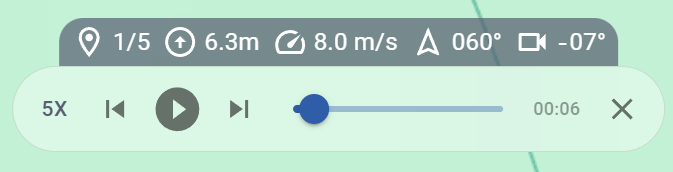
Simulation Enhancements
- The current waypoint index is now displayed during simulation
- Skip forward/back through waypoints
- The position slider works even when paused
- Added 5x playback speed
- The selected waypoint auto-updates in real time during playback
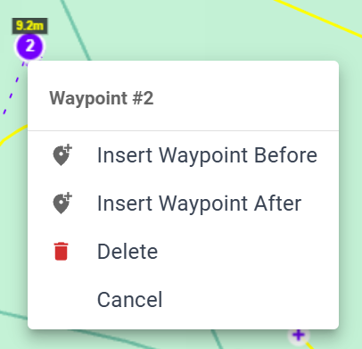
Waypoint & POI Context Menu
- Right-click on a waypoint or POI to access a quick action menu:
- Insert a waypoint before or after
- Delete the selected item
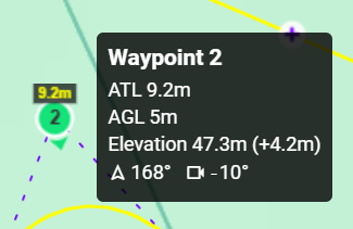
Waypoint Tooltip Improvements
- Tooltips now also show:
- Heading
- Gimbal pitch angle
Flight Library Upgrades
- Select and delete or move multiple flights/folders at once
- Drag & Drop support for moving flights
New Language Support
- Czech language added
2 Likes
The most recent version of the Mission Hub (v2) no longer displays the distance between waypoints. It used to. At some point, this feature disappeared.
Yes, it used to show all of the distances between waypoints.
I hope they will re-enable that feature or make it a user selectable option to see them all.
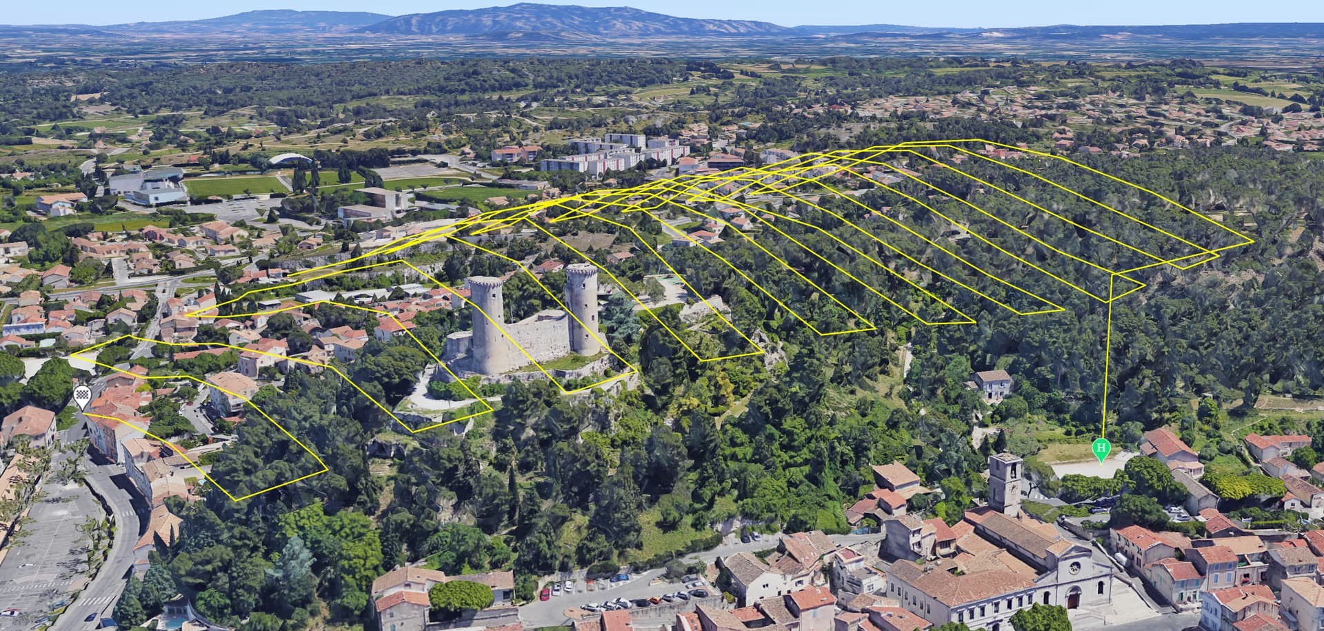
We’ve just added a new type of flight to the Litchi Hub - Area Mapping! Please make sure to share your feedback!
Get started video tutorial:

2 Likes
It is not clear how to specify the area to be mapped. Here are the steps I tried:
- Select “New Flight”.
- Select “Area Mapping”.
- Select “Create”.
- Clicking on the map places what appears to be a green home point icon.
- Clicking anywhere else on the map repositions the green home point icon.
How does one specify the area to be mapped?
Check the video in the post above! After you place the take off point, clicking again should start drawing a polygon
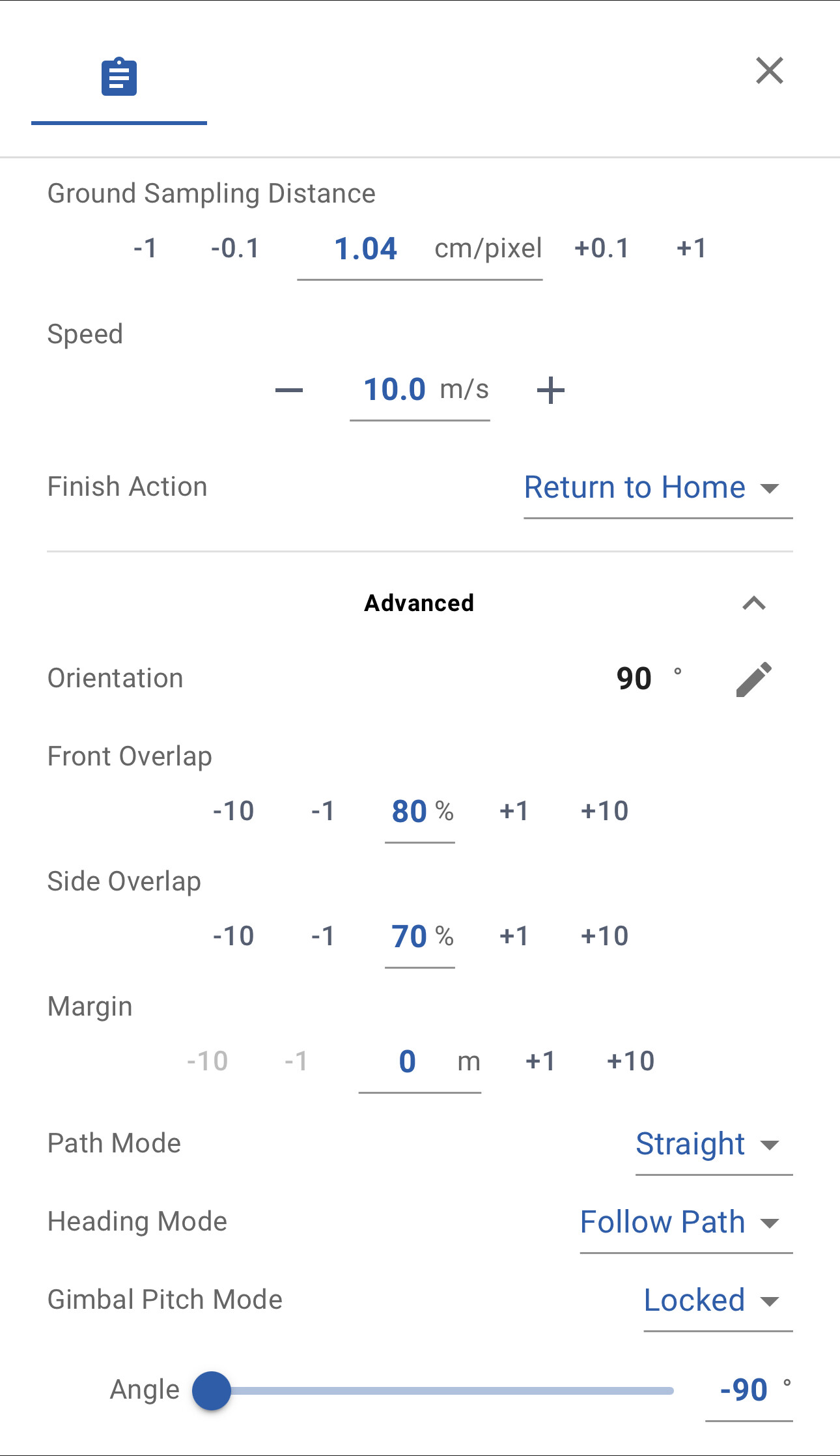
Can you specify or modify the percentages of overlap?
The front overlap can be changed by varying the photo interval. But, how do you vary the side overlap?
For me, multiple clicks just keep moving the home point around. I’m using Firefox on Windows 10.
Found the issue, should be fixed - sorry!
congratulations, would it be possible to use this method and say not photos, make movie? It would be used as a search and find tool. Just don’t need 60 photos, 1 movie will work fine.
Super !, now all that’s missing is the grid..
This addition of mapping to Litchi’s already phenomenal versatility is a MAJOR breakthrough, Vico. Hats off to the Litchi code meisters for upping the ante with this time-saving and lucrative professional-grade feature that will no doubt broaden Litchi’s customer base.
Now, with this development, the new Mission Hub can be viewed not just as an enhanced iteration of a trusted workhorse platform, but as quantum leap into a brand new realm offering robust commercial promise. Wow ! .
2 Likes