Thanks for the reply. Did find the ‘Undo’ and ‘Redo’ buttons which will come in handy. Will the ‘Clear’ button also be added in a future update? I also found this to be a handy feature from the previous version.
In the Flight Library I do like the ability to be able to toggle between alphabetical and previously worked on missions - very handy and easy to find missions when you have a long list of missions.
The new “Simulation” mode works well to preview the flight from the perspective of the drone’s camera. The simulation function can be selected while in all viewing modes (2D Map, 3D Map, Google Earth). However, it only works properly while in the “Google Earth” mode.
Suggestion: When the “Simulation” button is selected, automatically switch to “Google Earth” view. Otherwise, the simulation, which appears to play, is not visible.
An alternative would be to “gray out” the “Simulation” button unless one is in “Google Earth” view.
On the main display, selecting the drone icon displays the mission selection (Flights) menu. Selecting the icon of a monitor with horizontal lines displays the global settings panel (which includes the drone selection). I find the icon used for the mission selection menu to be less than obvious.
Suggestions:
Replace the drone icon with a mission icon as are displayed inside the mission menu.
Add “tool tips” so that when hovering over an icon, the purpose of that icon is displayed.
Selecting the hamburger icon (top left corner, three horizontal lines), displays the language and units selection. There should be an “X” to close that menu even though you can already close it by selecting anywhere in the map area.
The simulation actually works in all 3 viewing modes. In 3D map mode, it is not obvious if you are zoomed out too much, but there is an arrow representing the drone and moving along the path. In 2D map mode the Litchi drone icon moves along the path.
Feature Request - Camera Control Mode
No idea if the DJI SDK allows this - I am expecting not, since I never saw this done anywhere - but I would love to be able to switch my old DJI Mini 1 from normal photo to AEB mid-mission.
As is, I need multiples missions covering the same route for the points I want to generate HDR photos.
Cherry on top would be to be able to edit ISO and Shutter speed mid-mission, to accommodate different speeds during route.
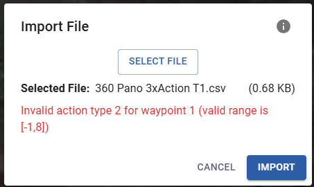
Pano action is not actually implemented in Litchi Pilot yet. But we will fix the CSV import. On another note, CSV import needs to be updated to support new hub features, currently it only imports the old flight format.
It would be possible with the Litchi waypoint engine for sure. Unsure if the onboard/DJI engine supports that however, but their latest engine does support many more types of waypoint action than they used to with older drone models.
I am using the Litchi app, not the Litchi Pilot (old DJI drone, not supported in Pilot), but I got it, thanks.
On that note, I noticed that action limit is gone. Is that correct? I run a waypoint with 73 actions, and while there were some hiccups, it appeared to have run all the actions.
Most new additions (new actions, path modes, etc) are only supported in Litchi Pilot. Unfortunately, we don’t have the resources to add these to the old app, as it’s based on a completely separate codebase.
The new Litchi Hub has no limit on the number of actions, although this may not work in the older app for some drone models.
Working in forestry, I envision incorporating CSV data into my geospatial analysis (eventually). A KML provides all of the same sort of info, so I suppose the CSV export would be more of a convenience.
Good afternoon, I finished a mission in the new Litchi Hub mission portal and after checking with the simulator that everything was fine, I saved the mission with the same name. I exported .KML (only export at the moment) and downloaded the new .LCZH format (I don’t know what it corresponds to). Wanting to transform it into .csv with the old Litchi Hub when I go to open the mission it is not recognized and it opens all the waypoints on the equator!!! Why??? Is it normal and can it be corrected??
Thanks