Many consumer drone models aren’t supported by the DJI SDK, making them incompatible with Litchi Pilot.
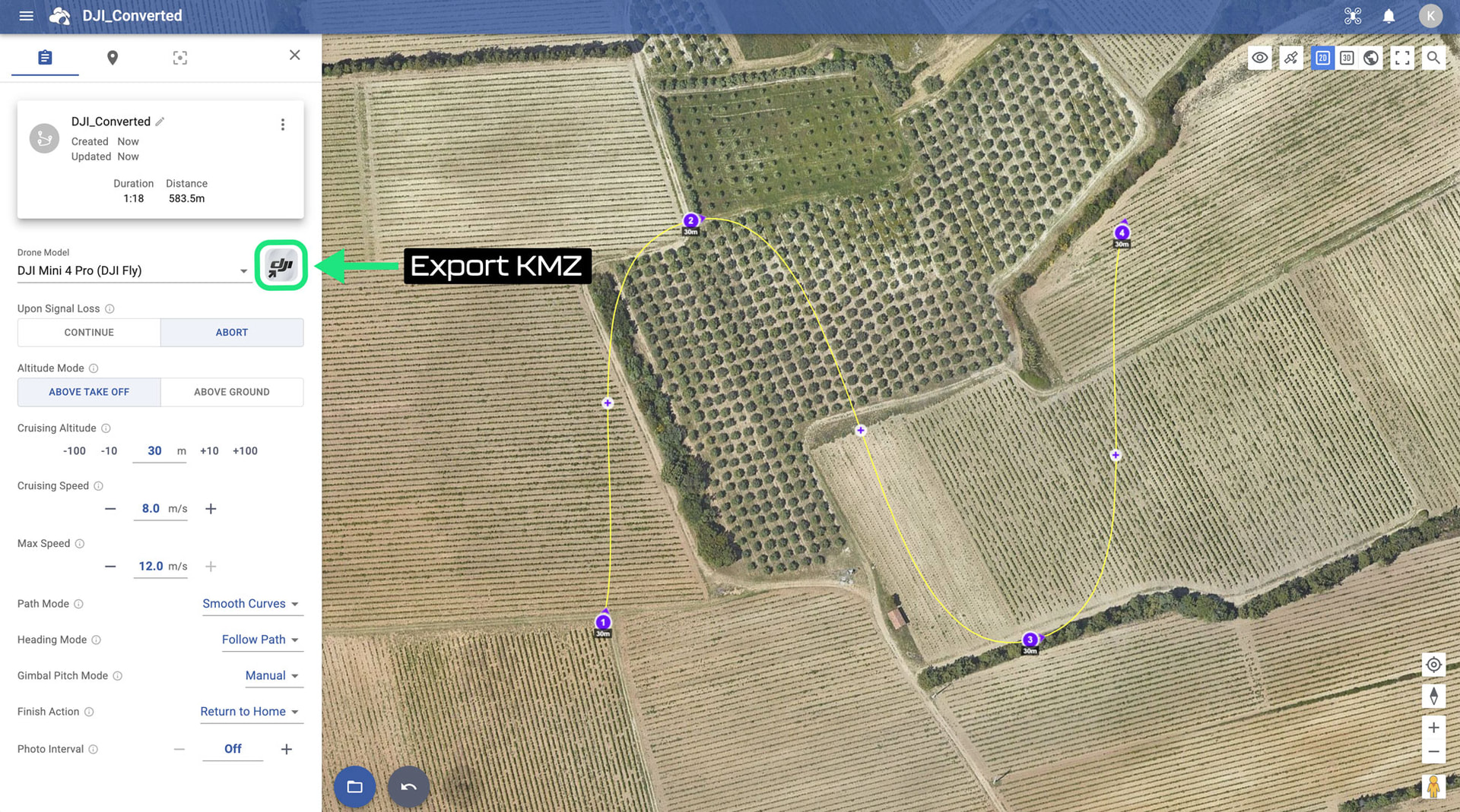
To work around this limitation, we’ve added a new feature to the Litchi Hub: the ability to export KMZ files. This lets you plan waypoint flights for any DJI drone that supports waypoint mode in the DJI Fly app.
Supported drone models:
Air 3 & Air 3S
Mavic 3, Mavic 3 Classic & Mavic 3 Pro
Mavic 4 Pro
Mini 4 Pro (has SDK support so we recommend flying with Litchi Pilot instead)
Mini 5 Pro
Step-by-Step Guide
1. Plan your flight in the new Litchi Hub
Head to https://hub.flylitchi.com/ to plan your waypoint flight, then export it to KMZ in the flight settings
Would that not equate to acquiring Litchi Pilot, and pay for the software all over again? I don’t have Litchi Pilot since I never had a Mini 3 series drone.
Yes, directly flying a Litchi mission with a Mini 4 Pro would require that you use the new Litchi Pilot app. If I’m not mistake, it is currently freely available since it is still in beta.
I downloaded a kmz file from hub 2.0 and used this technique to run a waypoint mission on my Air 3s. It flew a straight line mission without the usual rounding added by DJI. The drone also stopped at each waypoint. Is this the expected behavior?
I have previously used this technique with kmz files produced by Litchi mission utilities and a Hub 1.0 csv file. Those waypoint missions had the typical DJI rounding.
Thanks for the quick reply! I did have “path mode” set to “straight” because when I set the path mode to “curved turns”, the export dialogue replied “kmz export does not support curved turns flight mode”. I had set the “drone model” to “other” and “Smooth Curves” was not an option so I used curved turns. When I set “drone model” to Air 3S, the “smooth curves” option was available. I was then able to download the kmz file!
What is the difference between smooth and curved turns?
By the way, the “straight lines” option eliminated the danger of the drone descending lower than the waypoint!
You should see the difference when selecting between the two with an appropriate drone model. “Curved” is used by the Litchi engine where “Smooth” is used by the DJI engine.
I have encountered the same problem. Since I use DJI fly I have to export to kmz but it does not allow me to export the routes with “curves” at the waypoints, but only those with “soft curves” or “straight lines”. However, with the old cvs to kmz conversion system it accepted the “curves” at the waypoints and even in DJI fly you could see the track with the curves. Soft curves are difficult to control because the route can drop too much in altitude or widen too much where it shouldn’t.
You will need to explain what you mean by “soft curves” as that term is not used by either Litchi or DJI.
DJI Fly waypoints only support curved paths that pass through each waypoint. As a result, it is possible for the flight path to become lower (or higher) than an adjacent waypoint. It is also possible for DJI Fly to fly a straight line mission. However, such a mission must be loaded via a KMZ file as there is no way to select the path mode from within DJI Fly.
Ok. I understand now. What Litchi is calling “Smooth Curves” is referring to DJI’s method of making the flight path pass through each waypiont. Litchi’s method places a straight flight path between each pair of waypoints with the option to use curves at the locations of the waypoints.
Each method has their advantages and disadvantages. As you point out, DJI’s method may allow the flight path to become lower (or higher) than any of the waypoints used to create the path.
As DJI does not support Litchi’s style of curved flights, one cannot export that kind of path into a DJI KMZ file. Your only choices will be either straight lines or smooth curves.
When downloading the kmz (dji fly) from https://hub.flylitchi.com/ and uploading it to the dji fly app, the mission does not load, it just appears blank.
Yes, it was actually working without any problem before, but now the planned flight simply won’t load, I will continue testing to find out what the error is.
I’m flying a DJI Air 3S and have created a waypoint mission in Litichi Hub. I have tried and tried to import it into the DJI RC2 controller with no luck. I Rename the KMZ file exported by the Litchi Hub to the same name as the KMZ created by DJI Fly. Then replace the DJI KMZ with the Litchi Hub KMZ. When I go back into the waypoint missions on the controller it’s not there. The mission I created with 2 waypoints is still there. Could anyone please explain to me why this is happening? I’ve done it 10 times with the same results. Thanks guys!
I’m sorry to hear that. It can seem like a tedious process, but I work with people who do it all the time. So, I know the process does work.
That is the correct process (at least part of it).
This suggests a couple things. Either you are not copying the newly created mission over the existing mission OR you are copying the newly created mission over the wrong mission.
Assuming you know how to copy and replace files in the Android system, what you describe suggests that you are not replacing the mission you think you are replacing. What some people do is you create a new “dummy” mission in DJI Fly knowing that you are going to immediately replace it. This way, the new “dummy” mission will have the most recent modification date/time. Then, when looking at the missions through the Android file system, it is easy to sort the mission folders by date to see the mission folder with the latest modification time and replace the KMZ file within it with the new KMZ file.
If you have several missions in DJI Fly, load each of them one-by-one to see if you recognize the mission you created in Litchi’s Mission Hub (v2). This will tell you if you copied your new mission into the wrong folder.
Also, if you export the KMZ file that you imported into DJI Fly and send it to me, I can tell you whether it orginated in DJI Fly or Litchi’s Mission Hub (v2).
When I export the file out of Litchi, should it be kmz or csv? I’ve tried to export as csv and it says coming soon then use the converter to convert it to kmz?