Hello everyone,
I’m currently developing a new web tool for generating 3D grid survey waypoint missions, designed to work seamlessly with Litchi (for now). While it’s still in development, the tool is already functional, and I would love to gather feedback from interested users.
Key features include:
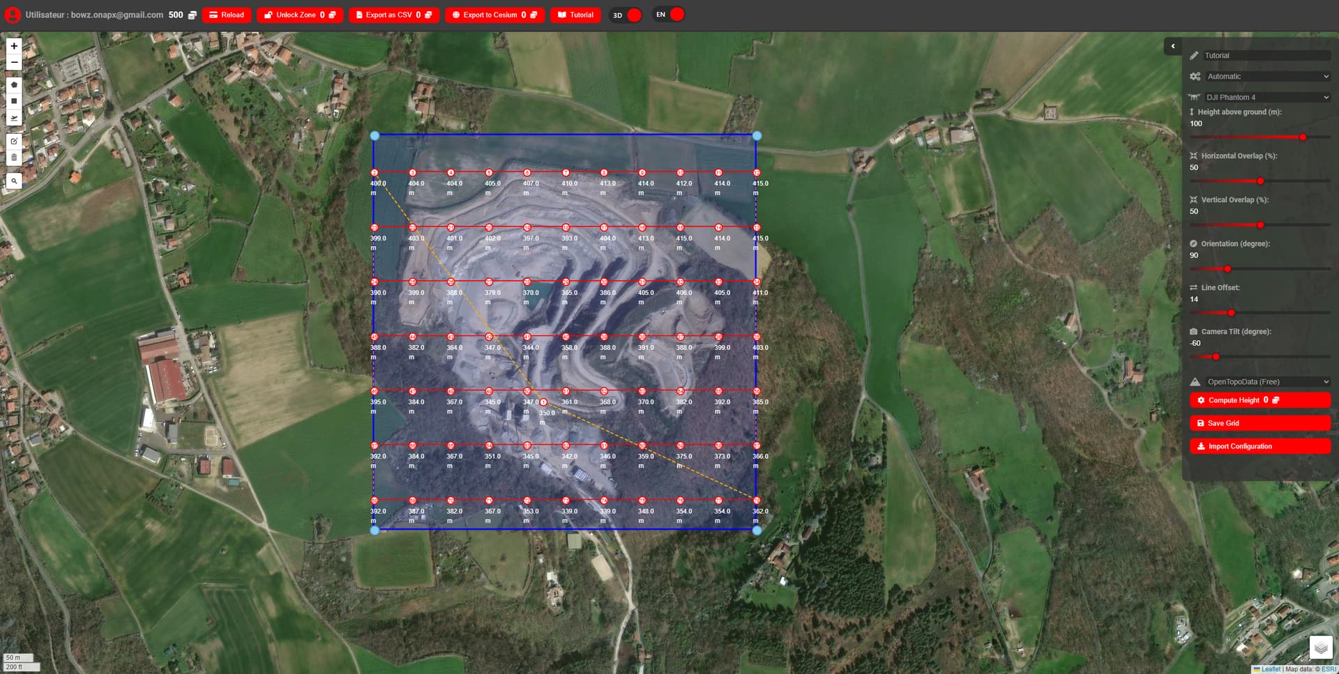
![]() Auto and Manual Grid Generation: Automatically generate optimized waypoint grids based on your drone’s camera specifications (focal length, sensor size, etc.) to ensure the best coverage—or manually adjust the grid directly on the map.
Auto and Manual Grid Generation: Automatically generate optimized waypoint grids based on your drone’s camera specifications (focal length, sensor size, etc.) to ensure the best coverage—or manually adjust the grid directly on the map.
![]() Custom Elevation Data Support: Import your own Digital Elevation Model (DEM) files (
Custom Elevation Data Support: Import your own Digital Elevation Model (DEM) files (.tiff format, EPSG:4326) for custom terrain data, or rely on OpenTopoData (free) or the Google Elevation API as default sources.
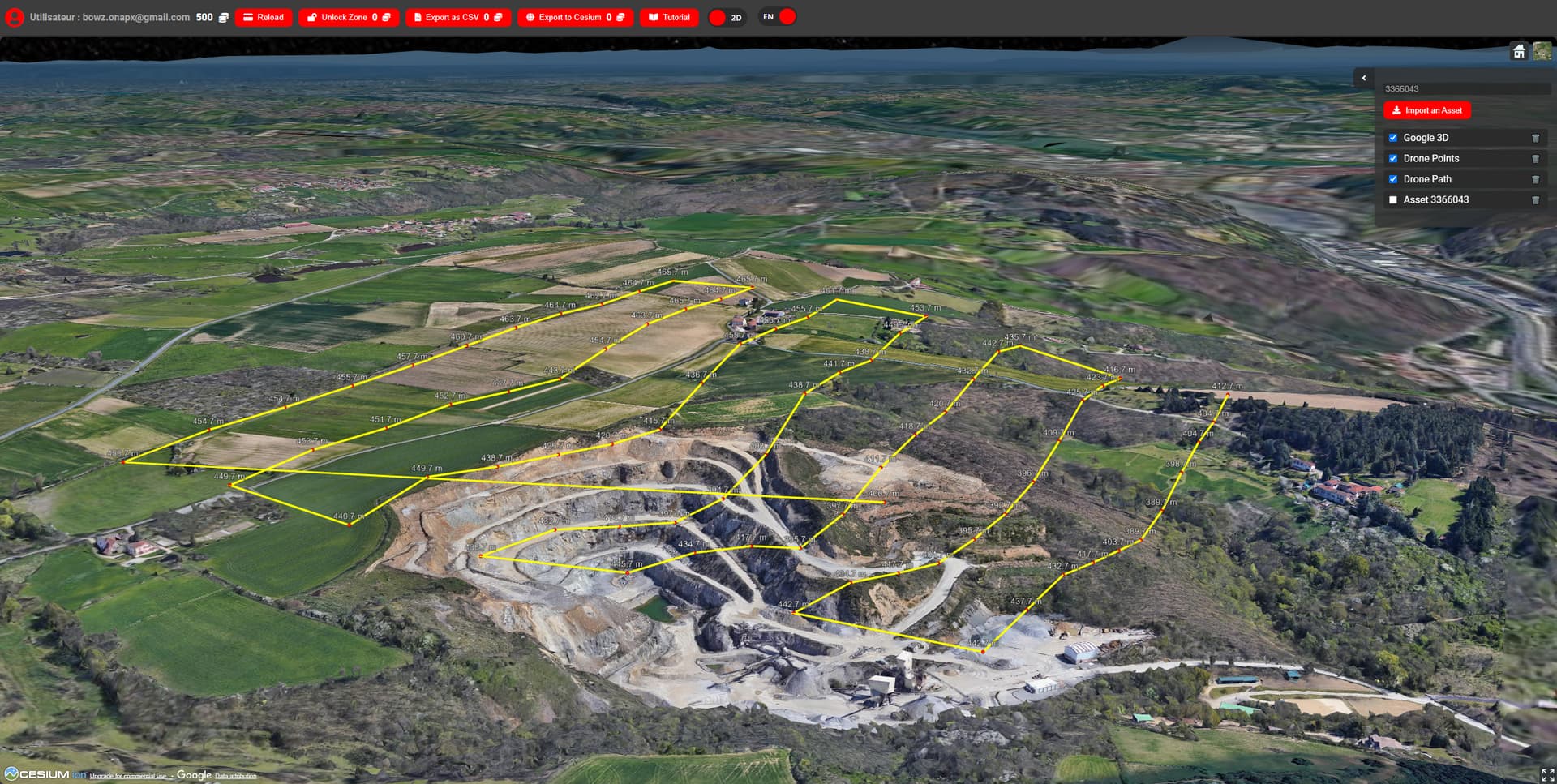
![]() 3D Scene Preview: A key feature is the integration with Cesium for 3D scene visualization. You can load your own 3D assets (photogrammetry meshes, point clouds, etc.) to preview your mission and ensure that waypoint paths avoid elevated obstacles.
3D Scene Preview: A key feature is the integration with Cesium for 3D scene visualization. You can load your own 3D assets (photogrammetry meshes, point clouds, etc.) to preview your mission and ensure that waypoint paths avoid elevated obstacles.
![]() Mission Saving & Management: Save, manage, and reload your missions directly from your account, making it easy to refine and reuse flight plans over time.
Mission Saving & Management: Save, manage, and reload your missions directly from your account, making it easy to refine and reuse flight plans over time.
![]() Export & Integration: Export waypoints to a .csv file ready for seamless integration into Litchi. The focus is on providing a flexible, accurate tool for drone survey planning, catering to both simple and complex missions.
Export & Integration: Export waypoints to a .csv file ready for seamless integration into Litchi. The focus is on providing a flexible, accurate tool for drone survey planning, catering to both simple and complex missions.
Although the tool already works well for basic survey missions—and I’m actively using it for my own projects—there are still a few bugs to iron out. However, I believe it’s ready for broader testing, and I would truly appreciate any feedback or suggestions.
 Upcoming features and plans:
![]() Custom mission designs: In the future, you’ll be able to design free-form missions, placing waypoints, curves (Bezier, etc.), and shapes directly in the 3D scene, offering greater flexibility for terrain-following missions and complex route planning.
Custom mission designs: In the future, you’ll be able to design free-form missions, placing waypoints, curves (Bezier, etc.), and shapes directly in the 3D scene, offering greater flexibility for terrain-following missions and complex route planning.
![]() Advanced waypoint editing: Gain more control over waypoint altitudes, speed settings, and camera actions to adapt better to diverse surveying needs.
Advanced waypoint editing: Gain more control over waypoint altitudes, speed settings, and camera actions to adapt better to diverse surveying needs.
![]() Additional customization: Enhanced export options for more file formats, and potential integration with other flight planning tools (Pix4D, DroneDeploy, DJI Pilot, QGroundControl, etc.).
Additional customization: Enhanced export options for more file formats, and potential integration with other flight planning tools (Pix4D, DroneDeploy, DJI Pilot, QGroundControl, etc.).
 Monetization & Beta Testing Offer
To finance the development and cover non-free services like the Google Elevation API, I’ve implemented a credit-based system, where you purchase credits to unlock zones for mission generation and export.
However, to encourage early feedback, all new users (“beta testers”) will receive 500 free credits upon registration during the first two months. Once a zone is unlocked, it will be saved to your account, and you will be able to edit as many missions as you want.
The tool uses a secure Firebase authentication system for registration. By signing up now, you’ll receive free credits and be able to save and manage your missions for future use.
If this sounds interesting, feel free to try it out and share your feedback! Your input will directly shape future improvements and new features.
![]() Try it here: https://www.dronage.fr
Try it here: https://www.dronage.fr