Hola probé la aplicación beta hub para planificar un vuelo para una planimetría, salió todo super bien el dron es un Mini 3 pro, el cual se comporto bien en vuelo al igual que la app Litchi Pilot el programa se comporto fluido sin problemas.
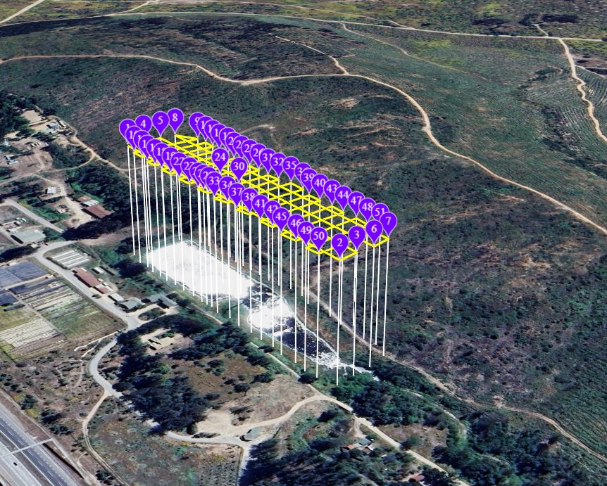
Hola trate de cargar un vuelo desde Google earth, pre diseñado pero la plataforma Litchi hub, no lo cargo será un error o aun no se podrá no esta habilitado, aunque existe en la plataforma la posibilidad de cargar el archivo KMZ .
The new Mission Hub does not yet support the import of Google Earth KML files. How did you import from Google Earth?
No, you cannot import KMZ files either. It is important to know that there are two types of KMZ files. There is a Google Earth KMZ file and there is a DJI KMZ file. They are different file types even though they use the same file extension. When mentioning a KMZ file, it is important to specify which type you are referring to, Google Earth or DJI.
2 Likes
Does this support for Mavic AIR 2?
No.
The regular Litchi app is compatible with the Mavic Air 2:
Hi. When flying an orbit mission with the heading set to ‘POI (center of orbit)’, the photos captured are not aligned with the orbit center and appear off-axis. Is there something I may be configuring incorrectly? Any guidance would be appreciated.
Litchi Pilot Beta has no Orbit Mode (yet).
Have a look at these topics:
Orbit Mode: Drone Not Correctly Pointing at Central POI When Taking Photos
Odd orbit behavior Litchi Pilot + new Litchi Hub
Orbit mode centerpoint
Looks like the problem is really with Orbit mode. When I do the same orbit using waypoints and set the drone to face the same POI, the photos come out aligned. But in Orbit mode they don’t stay centered.
Hello I would like to present my spherical panorama idea for drones MINI 3, MINI 3 PRO and MINI 4 PRO. These drones if you take spherical pano by default app can take just 12 megapixel photos and camera only in landscape mode. This pano cover 99% of sphere, but at the top there is small piece missing. Here you can see example Google Maps
Full sphere - camera orientation. If camera is switched to the portrait mode, drone is able to see 100% full spherical image. So there is no need to fill any part of the panorama.
Resolution increasing - as mentioned before, original app can take panorama source images just as 12 megapixel. If you stich 12 megapixels images, result spherical image is about 175 megapixel.
I can increas resolution by taking 48 megapixels photos. Then resulted image is about 650 megapixel spherical panorama.
I have one more question to panorama mode. it will be very good if it will be possible to focus manually. Auto focus can fail when pointing to clouds, so it will be much better to fix focus before first image and later keep focus the same.
1 Like
When to get VR mode on Pilot Beta?
We suggest using DroneMask for FPV flight