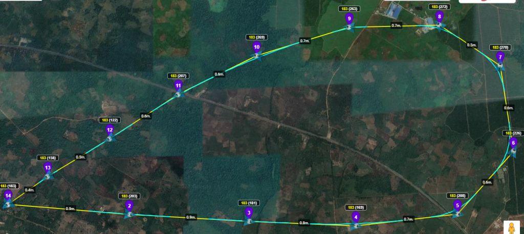
Those after-market batteries are the Achilles heel of the old Phantom 3 drones. The crash came literally in the last 5 seconds of an 8.5-mile round trip when the drone’s motors were very loud and real close. Using the Litchi flight path as a guide, I expect to fish the drone out of a tree when dawn breaks.
As luck would have it the expected rain storm never materialized, so if there was a soft landing, I might be able to get this bird airborne once again after giving it adequate time to dry out from the dew. The battery will probably be fine as well, once recharged.
I am certain there was a soft landing because it was close enough to hear the impact if it had lost power over bare ground.
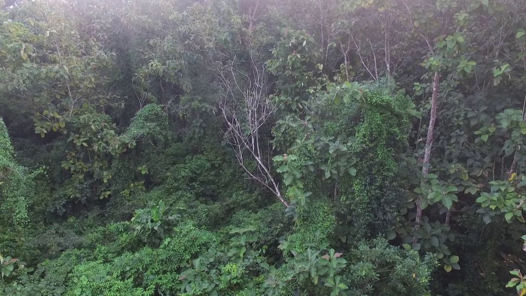
Dawn brought good news today. I placed a bounty on the renegade drone and when I heard whoopin’ and hollerin’ in the nearby overgrown teak plantation, I knew the search was over. I was amazed to see that there was zero damage to the camera, airframe, or props, and when I played back the footage I found out why the drone emerged unscathed. This is the view at waypoint number 6.
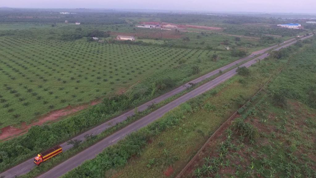
Turns out that 8.5 miles round trip is 0.5 miles too far for a Phantom 3 Standard to fly on a single battery charge, and so the drone did a controlled descent into the middle of a nearby teak tree plantation. If I’d just searched a short distance further afield, I’d have seen the strobe flashing where the drone lay upside down in the undergrowth. Coming up on Litchi waypoint number 5 right before the highway.
The battery seems to be charging fine, and later on, I’ll give the drone a test flight. But for a twig encountered at about 50 feet above the ground, that drone would have made a textbook landing. Hitting that twig, the Phantom flipped upside down and tumbled into the soft cushion of the undergrowth.
All things considered, I’ll henceforth limit my drone’s Litchi waypoint flights to 7.5 miles round trip, to leave an adequate margin of error in case headwinds winds are encountered on the way back.
You still haven’t found the correct answer to your question. 17.9 mph or 28.8 km/h is dji’s manufacturer’s maximum speed with obstacle avoidance sensors enabled and is listed in the user manuals for most drones. It has nothing to do with litchi and maximum speed at waypoints.
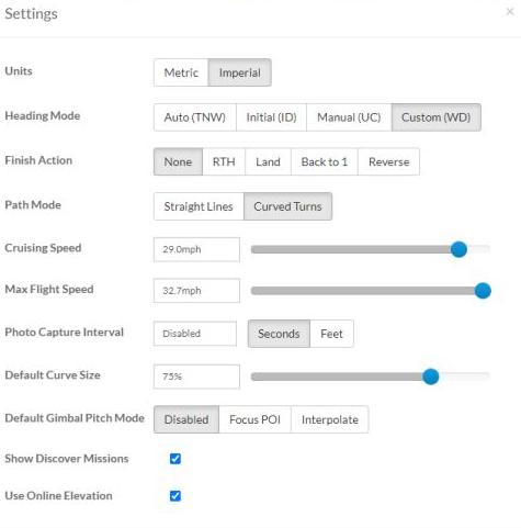
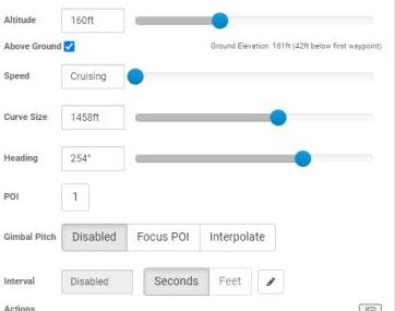
In Litchi’s global waypoint mission settings shown above, I’ve set my cruising speed for all waypoints at 29mph whenever the speed slider-selector is left at the default of “cruise speed”. as shown below in the settings page for an individual waypoint.
Your passing mention above, that most drones are not rated to fly with obstacle avoidance running at speeds above 28.8 mph, may explain why I was seeing that string of stop and hover interruptions during yesterday’s 7-mile Litchi waypoint test flight.
That flight’s speed was set at 28 mph as a global setting for all waypoints, but with the obstacle avoidance left running because it had no adverse effect on many previous flights. Hedging my bets I will henceforth triple-check to ensure that obstacle avoidance in all directions is set to the OFF position.
If conventional wisdom is to be believed, I might even see improved battery range once all the Spidey-sense bells and whistles have been disengaged on this Mavic Pro1 as I subject it to more grueling long-range sorties over the coming days.
Cruising speed is the total speed for all waypoints, but it is by no means the maximum.
Why you and tribar use the term maximum cruising speed is beyond me.
I’ve noticed that RTH kicks in a lot sooner with the speed set at 28 mph, than was the case when all my drone’s Litchi flights were set at the same speed of 17.9 mph.
I found that when the Litcghi mission speed was 17.9 mph, the drone landed back at the launch point after a 6-mile round-trip Litchi waypoint mission with a 20% battery charge remaining, though winds did often reduce that figure to as low as 15% battery charge remaining.
With my new Litchi mission speed setting of between 28 mph and 29 mph, I’ve noticed that the battery level is typically at 30% on arrival back at the launch point. I went into DJI Go4 to adjust the “Low Battery Level” warning to 20%, and the “Critically Low” warning to 15%, but that made no difference to the average 30% battery level that remains after completing Litchi missions at the new higher speeds around 28 mph.
If I could find a setting that will delay the onset of RTH until a 20% battery level is predicted on arrival at the launch point, I am certain that 8-mile round-trip Litchi waypoint missions flown at 29 mph can become possible and even routine.
I’m about to launch a flight into partially cloudy but still skies, prior to which I will be sure and click that battery icon that I never knew held a menu that includes a means to specify battery charge levels on arrival at the home point. I doff my hat, sir. Back in a while.
Clicking the battery icon with the drone powered up and the controller plugged to the iPhone I saw for the first time that battery menu whose existence you kindly pointed out today, displaying the settings I made yesterday via DJI Go4’s battery level alert settings page, namely that a 20% battery charge level be assigned as the threshold for a low battery warning, with 15% the point at which a critically low battery charge level audio alert should sound.
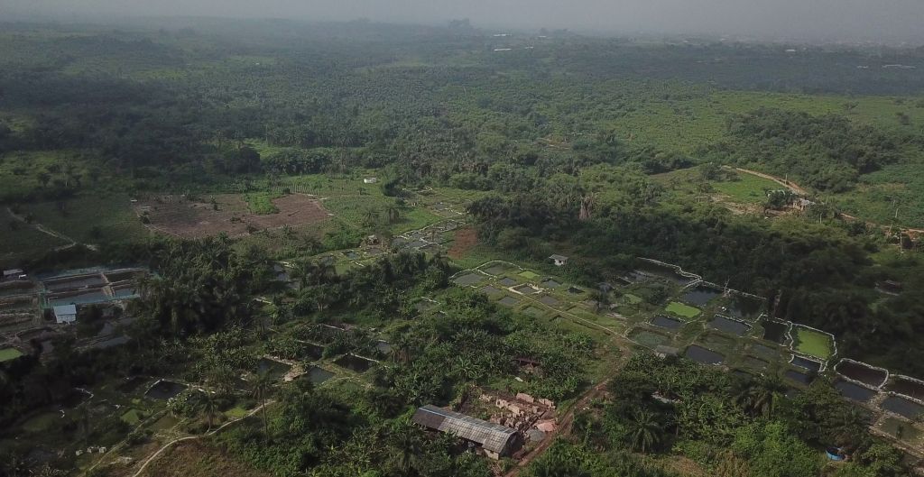
Not long after this view of catfish ponds under slate grey skies was captured about 3 miles out this morning, the drone went into RTH and arrived at the launch point with 30% battery power.
While I still haven’t stumbled on a way by which to instruct the drone via Litchi or DJI Go4 to schedule arrival at home with 20% and not 30% battery charge, disabling the obstacle avoidance did result in a very smooth flight with only a couple of minor pauses that occurred at waypoints located along tight swooping curves.
RTH treshhold is NOT user configurable.
Warning levels are (as you already mentioned), but they only give a warning.
RTH treshhold is constantly calculated during flight using average powerconsumption per flown distance and the current distance to the homepoint.
The drone assumes it needs the same amount of power to RTH as it has been using during flight relative to the RTH distance.
Example:
Flying with headwind will trigger RTH sooner than flying with tailwind.
Resulting in an ‘unexpected’ high % left upon landing (headwind scenario), and NOT making it back/forced landing (tailwind scenario).
Ah, I see. There is no means to adjust the RTH trigger point. My observations suggest that Litchi errs on the side of caution when the speed of the drone approaches the upper Litchi waypoint mission speed limit of 32.7 mph, by triggering RTH a tad earlier in each flight than it does when the drone’s speed is a more sedate 18 mph.
With that RTH trigger point now eliminated as a user-configurable variable, I’ll have to content myself with keeping all waypoint missions shorter than 7 miles round trip so as to prevent RTH interruptions before the entire course is completed. This clarifying explanation from Tribar is appreciated as always.
I’ve learned more about the nuances of Litchi waypoint mission planning over the past few weeks as a member of this forum than I’d accumulated throughout the preceding 2 years of Litchi usage during which my acquisition of knowledge was mostly by bumbling trial and error.
I’ve read of people sending drones on one-way sorties set up to land at remote locations and I’ve thought of trying it for sure.
Takes a leap of faith to disable low battery smart RTH, but with that done it should be possible to create a flight path that includes a pause at the destination waypoint that is of sufficient duration to exhaust the battery down to 10%, at which point a controlled landing will occur.
Litchi apparently requires that the last waypoint be located at or close to the launch point, so for such a one-way waypoint mission to be flyable with the low battery smart RTH disabled, one could program a regular round trip mission that ends at the launch point, along whose course an in-flight hovering delay sufficient to use up the remaining battery charge could be specified for the waypoint placed at the actual final destination of that mission.
I always use the dynamic home point and the drone flies to the place where I am after the end of the mission. I see the changed point of the house on the map. Even if the drone loses connection, it will fly to the last recorded point.
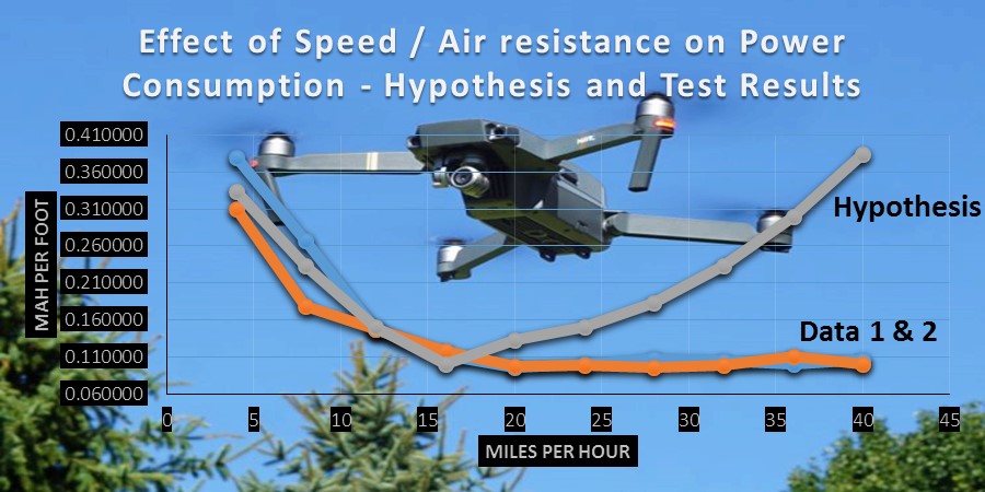
Well, I have tried out Litchi waypoint mission airspeeds ranging from 30 mph down to 20 mph, and my findings disagree with the graph shown below here which suggests that Mavic Pro drones flying at 27mph to 30mph consume battery power at a more efficient rate than if the speed were a slower 20mph or below.
My observation has been that the faster the drone flies above 20 mph, the earlier along the Litchi waypoint flight path the drone will revert to low-battery RTH and make a beeline for home. In summary, the maximum distance I’ve been able to fly my Mavic Pro1, Mavic Pro1 Platinum, and Phantom 3 Standard, regardless of airspeed, remains 6.1 miles round trip, which is typically completed at the 20-minute mark.
The drones that were used by those high school students to generate the data for their battery efficiency graph may have been equipped with brand new batteries, which could possibly explain the difference between their test results and mine. Looks like I’ll need to go the whole hog and buy a Mavic Pro 2 or Mavic Pro 2 Zoom, in order to squeeze a little more range out of each Litchi waypoint mission.
So there you have it fellow armchair aviators, slow and steady will win the race if the objective is to maximize round-trip distance per battery charge. The Litchi forum official guinea pig hath spoketh, for the avoidance of doubt.