You will not be able to fly further than 2.48 miles from take off.
In my capacity as the self-appointed unofficial Litchi waypoint mission guinea-pig, I intend to launch a sortie of 8-miles total distance covered round trip as soon as this line of tropical storms passes through the area. The skies are grey right now, or that test would already have been underway.
At the very worst, the drone will perform a low battery RTH before reaching its turnaround point located 4 miles from the launch point. Over the past couple of years I’ve routinely sent my Mavic Pro and my ancient Phantom 3 Standard on 6-mile round trips lasting 21 minutes, but having now seen that the Mavic Pro does indeed consume less battery power per unit distance covered at 25 mph than is the case at 17.9 mph, I’m reasonably confident that the drone will return from an 8-mile round trip lasting 22 minutes with 20% battery charge level remaining.
Now the wind could pick up and thwart my dastardly flight plan, but I feel oddly compelled to perform this experiment now that my confidence is up with regards to flying at faster speeds for improved battery economy. Wish me luck hehe.
A waypoint mission with a waypoint located more than 2.48 miles from take off won’t even start.
1 Like

I took another look at the Mission Hub flight path my Mavic Pro flew today and realized that a circle of 2.48 miles radius that is centered on the departure point may in fact encompass the entirety of this waypoint mission, which would explain why the drone departed and returned normally.
My second longer test flight was scuppered by another storm as dusk gathered here, but I’ll attempt a longer 8-mile round trip waypoint flight when the morning mist clears tomorrow, weather permitting. With the new generation of DJI drones capable of staying aloft for up to 30 minutes, I’m hoping, fingers crossed, that Litchi may have expanded that 2.48-mile radius circle to permit waypoint missions that reach out a couple of miles further afield than in the past.
Here’s hoping I’ll have some good news to share tomorrow.
If the bird refuses to budge when I hit the go button, I’ll know for sure that the 2.48-mile radius circle within which the flight path must fall, remains unchanged.
I stumbled on this discussion at the Mavic Pilot’s forum on the subject of whether Litchi imposes a maximum allowable radius of travel from the launch point.
Litchi Waypoints radius? (max distance from starting point) | DJI Mavic, Air & Mini Drone Community

I was in such a hurry to launch my 7.9-mile round trip Litchi waypoint mission that I clean forgot to remove the goldfish bowl covering the camera, which of course resulted in poorly focused footage, reminiscent of my vision after a beer or two, getting recorded en-route.
Up until the moment that I played back the recorded footage, I was convinced that the mission had been a resounding success and that the drone had covered 4 country miles outbound, then circled a friend’s house at the other end of a gigantic palm tree plantation, before heading back to base. I typically turn off my controller once the drone is on its way, so as to prevent the disconcerting break-dancing gimbal effect that sometimes occurs when the link between controller and drone starts to break up mid-flight.
When I looked over the footage recorded during this flight, however, I noted that the drone had other ideas, after computing the battery power it would require to complete my programmed mission. Just 200 yards short of the turn-around point, the Mavic Pro slammed on the brakes, spun around, rose to RTH altitude, and called it a day by returning to base while the going was good.
Ever willing to try one more roll of the dice, I’ve decided to step up the speed from 25 mph to 27 mph and run the same route again when the weather breaks, in the hopes of completing that same mission without having RTH kick in before the turnaround point is reached.
Good thing I’m not a gambler because I’d lose my shirt every time for sure. That said, I am tempting fate by pushing this Mavic Pro to reach that mythical 8-mile round trip mark, so hopefully, this compulsion to push my luck won’t result in any wailing and gnashing of teeth after this next test I’m planning already
1 Like
My flight log has been updated to include today’s test flight. Calculating the total miles covered is going to become a bit more complicated now that my drone’s cruising speed has been increased from 18 mph to 27 mph.
Ignoring the last couple of flights that traveled at 25 mph, my total distance stands at 140 hours multiplied by 17.9 mph, which comes to 2,500 miles. Over in the Mavic Pilot forum, I thought I’d set a record when my drones’ cumulative mileage exceeded 2,000 miles, but then someone else published their Air Data page as evidence of over 7,000 miles logged. So much for that attempted boast haha.
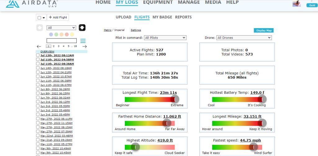
according to that, your total mileage is 650 miles
I’m surprised you were able to fly a waypoint mission further than 2.48 miles (4000 meters) from the take off point.
This is a limit in the DJI SDK.
So either this limit has changed, or Litchi found a way to exceed it.
…
After writing the above you posted an Airdata overview of your flights, including the one you wrote about above (Jul 12th, 2022 08:12AM).
This overview shows 'Farthest Home Distance: 11.062 ft".
This is still withing the 2.48 miles / 4000 meters range.
I don’t want to draw conclusions, but …
The takeoff point does not matter if it is enabled on the dynamic
UAV Air Data only records miles covered within the RC controller’s signal range. To arrive at the true figure, I’ve had to rely on the accurately tallied cumulative number of hours flown, which I then multiply by the speed of 17.9 mph, to arrive at the true distance covered both within the controller’s signal range and beyond it.
to do that calculation you need the average speed, the drone isn’t going to do 17.9 MPH all the way round, its like you driving its going to slow for curves before accelerating out of them
Wrong again.
You can set a Dynamic Homepoint,
The take off point does NOT change.
I do find that Farthest Distance from Home tally baffling because that is barely two miles, whereas my drones have flown numerous missions where the turnaround point was 3 miles away from the launch point. I can only presume that the figure of under 2 miles is based on a flawed or incomplete computation by UAV Air data.
The distance one way for this latest test flight was definitely a good 4 miles. To satisfy my curiosity I’ll check for the precise distance using Google Earth’s handy ruler tool, and report back later on.
I’m really anxious to launch another flight along the same route with a faster speed of 27 mph, but as luck would have it, a tropical rain storm is in progress pounding the tin roof outside as I type these words.
Despite this minor weather related drawback I do love the rain, and can only hope that global warming doesn’t shorten the annual rainy season that runs between June and September here, before tapering off and giving way to a dusty and hot dry season.
This is a good point. The drone does slow down on turns, so my 2,500-mile tally may in fact be a bit ambitious of a total to declare, though perhaps not quite on the optimistic level of a fisherman’s tale about the one that got away.
Using Google Earth Pro’s distance measuring ruler tool, the one-way distance between the launch point and turnaround destination point is precisely 3.75 miles, just a hair short of the 4 mile distance I presumed it to be. The total round trip distance of the Litchi waypoint route is therefore accurate at 7.9 miles, given that I always use gradual turns that cover a bit more distance than a sudden about-turn at the destination.
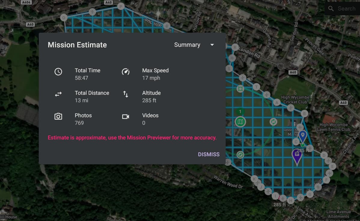
This is a 13 mile long mapping mission, with a maximum speed of 17 MPH, it takes just under an hour, so lets say the average speed is 13MPH that’s 4 MPH slower than the maximum speed, so that’s 23% slower
1 Like
To start the mission, the take-off point does not matter. It is enough to turn on the drone, take off and land, wait for the house point to be recorded and move it on the map, the mission will start. I already asked this question to the developer, for the simulator it works the same way, you have to launch the drone in the simulator at home, land, move the point home, and then the virtual mission starts at least 20 km away. This is inconvenient for a simulator, and in real flight such a distance is almost never required.
Pushed my luck a tad too far today, and my Phantom 3 Standard is currently AWOL. Heard it homing in over a tree canopy within 75 meters of the launch point at the end of an 8.5-mile round trip but then the engines abruptly shut down. The search resumes at daybreak tomorrow, and I suspect the drone is up in a tree, rather than in the undergrowth.
My internet forum research suggests there is a consensus that a Phantom 3 or Mavic Pro1 cruising at a decent clip of about 27mph would indeed maximize its distance covered per fully charged battery, so I decided to see how the Phantom compared to the Mavic Pro in terms of distance covered without reverting to smart RTH due to low battery levels en route.
Even before I locate the Phantom, my hunch is that the after-market battery in that drone shut off suddenly rather than retain enough power to make possible a controlled landing. This happened once before on arrival from a 6-mile round trip Litchi mission, and that Phantom 3S plummeted onto the hard ground in front of me from 140 feet AGL, showering camera parts on impact.
Buying after-market Phantom and Mavic Pro1 batteries on eBay is a necessary gamble now that original DJI batteries for those ancient models are a rarity, but after two power loss crashes in a row, I see a pattern of such alternative batteries shutting off at low charge levels. Buyer beware.
Ouch! That’s a terrible feeling when your drone doesn’t make it back home.
Hope you find it, and it.s ok