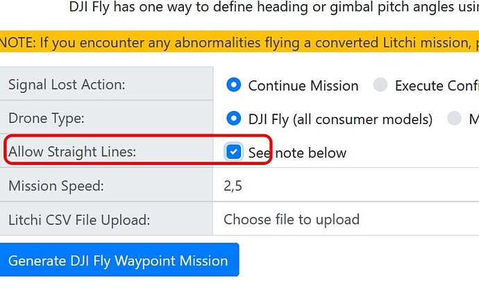
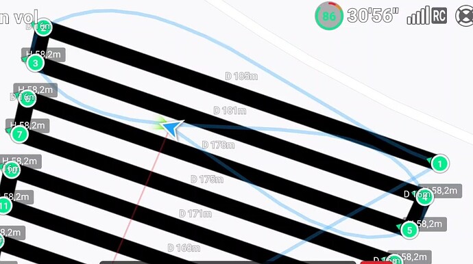
I give it a shot. Would be nice if ‘Take Photo" started interval photo mode’.
Thanks for the help!
Didn’t try but I don’t think… it’s DJI Fly not LITCHI ![]()
tried it. ‘Take Photo’ just takes a single photo as expected.
Timed shots work great!
yes, tried it first without that checkbox and got a VERY loopy mission!
Interval photo capture (distance or time) is supported in the WPML language. However, it is only supported in DJI’s enterprise drones. For consumer drones (such as the Mini 4), one has to use the method that Patrick has described.
Hi @wesbarris! Fantastic tool, thank you so much for making it available publicly!
Have you open sourced the code for the converter tool? I’m looking to implement a similar logic in an application I’m working on and it would be a great help if your converter code was available for reference. Thanks!
I currently do not have plans on making my code publicly available.
Given that DJI’s native waypoint facility is a ponderous and unnecessarily complicated product to utilize, the availability of this handy converter is the only reason I have my sights set on buying a Mavic 3 in the near future.
When I do acquire a Mavic 3 I will not hesitate to pay for the converter in the event that is no longer freeware by then.
Perhaps someone knowledgeable in this thread can help me convert a Litchi waypoint flight to a Mavic 3 Pro waypoint flight using Wes Barris’s Litchi to DJI Fly converter. I have successfully downloaded Wes’s converted KMZ file, but when trying to import it into the DJI Fly app on my DJI RC, I can’t find the “waypoint” folder in the Android directory as he instructs. There is a mention of enabling USB debugging to find the “waypoint” directory, but I can’t find that option on my DJI RC either. Any suggestions are greatly appreciated.
The following instructions are for accessing the flight logs but the same (or similar) procedure may work for accessing the waypoints folder.
I have a couple of questions for Wes Barris about this Litchi to DJI waypoint mission converter, now that I have experimented with it in anticipation of when my newly purchased eBay Air 3 drone finally arrives in the post.
As a test of the converter, I used the Litchi Mission Hub menu option of exporting a Litchi waypoint mission as a KML file to my computer’s desktop, which I then copied and pasted into the waypoint mission converter as per the instructions. I set the cruise speed for 12 meters per second which is about 27 mph for the mission and then hit the execute button.
I noted that the converted waypoint mission was of the expected shape, but that the waypoint count had dramatically increased from about 30 waypoints to over 100. Since I haven’t yet taken possession of my inbound Air3, the waypoint icon in DJI Fly is not yet visible or accessible, so I cannot as yet resolve my questions by patient experimentation with DJI Fly’s waypoint mission editor.
Hoping my presumption is correct that the number of waypoints can be reduced by editing the Litchi waypoint mission once it has been converted and saved in DJI Fly, I would also like to find out whether the two key variables that are NOT available in Litchi once a drone ranges out beyond RC signal range, namely the camera gimbal downward tilt angle and the zoom image magnification setting, can be assigned to selected waypoints by editing the newly converted Litchi to DJI Fly waypoint mission, such that gimbal angle and zoom settings will autonomously adjust on the fly, to conform with pre-assigned values even if RC connectivity is lost during such a waypoint mission.
Any clarification that can be offered about these questions would be greatly appreciated.
The very first line in the Mission Converter Utility CLEARLY states it converts a Litchi Mission CSV file, NOT a KML file.
Also right above the blue “Generate DJI Fly Waypoint Mission” it says: “Litchi CSV File Upload:”
I live in the EU where missions are aborted when signal is lost.
I don’t know if there are other regions where this is the case.
Since you have drones that use the DJI GO(4) app, you should at least read the July 2022 updates notes in the What’s New section.
Apologies for my laxity in reading the instructions and product updates, Tribar. My computer knowledge is limited and as such I can be hasty in asking questions whose answers could have been found by more carefully studying previously available documentation.
I will now take it upon myself to carefully peruse the waypoint converter instructions so that my future questions will not highlight my failure to research the topic adequately, as did my earlier questions.
TriBar has already explained that this utility was written to convert a Litchi CSV file to DJI waypoints.

This is probably more than you wanted to know but there is a reason why a 30 waypoint mission is converted to a 100+ waypoint mission when importing a KML 3D path. The ability for this utility to also import KML/KMZ files was the result of a request to convert Google Earth data directly to DJI waypoint missions. A waypoint mission with curved turns is approximated using a KML path with many short line segments. This is why the number of waypoints dramatically increases when importing KML data made from a curved-turn mission. If that doesn’t make sense just know that the utility is best used to convert from Litchi CSV files.
With this sobering realization that all the questions I asked have long ago been addressed in the published instructions, I will now adopt a more methodical learning approach in a bid to mitigate the usual chaos that all too often defines my life these days.
Reminds me of the adage " When all else fails, read the instructions." My interest in the procedure for using this Litchi to DJI Fly waypoint mission file converter went off the charts as soon as I scored an affordably priced Air 3 a couple of days ago, even though its actual delivery is still weeks away by snail mail.
In my haste to test the converter, however, I decided to try and wing it by simply plugging into the file conversion utility the only waypoint mission file type that I was able to export from Litchi Mission Hub’s saved mission listing, namely those bearing the KMLsuffix.
All things considered, I shud of stood in bed, and will now avoid the limelight until I am prepared with better-informed questions to ask about this magical bridge between Litchi and DJI Fly that I must traverse, even if that necessitates yes, the much-feared reading of directions long before that step becomes the only remaining option.
Buonasera, sono nuovo nel gruppo. Sono anche un felice proprietario di un Mavic 3 Classic e sto imparando a usare i Waypoins che genero con l’hub della missione. Ho rilevato un problema, una volta che i file kml sono stati installati sul telecomando DJI RC, se i file sono troppo complessi, l’applicazione DjiFly si blocca o il sistema WP funziona molto lentamente e faccio fatica a modificare le missioni. Ti è mai successo? C’è una soluzione?( google traduction… scusa)
Mission Hub - Litchi? m=GZlM76RN4u
That’s typical for the underpowered DJI RC.
If you are able to share such a waypoint mission, then perhaps one of us can give you some advice on how to simplify it without loosing it’s objectives.
Here you can read how to share a mission:

