So I like many have had huge learning curves with the elevation AGL and Above Waypoint etc.
I got around this by plotting my points and then exporting a KML 3D Path in settngs. Then importing that KML path into Google Earth and seeing an accurate representation of the flight path at actual height.
My problem now is that in the online Litchi website page, the map has areas with NO elevation data or hugely incorrect elevation data.
I know this because i open a mission that i have done the process and saved and flown numerous times. But when i plot a new waypoint in a different area at 30m i look on Google earth and it is 200m in the sky.
I set the elevation to -200 and still on Google Earth it is like 60m high.
Please help or explain or check the Litchi Map Elevation Data.
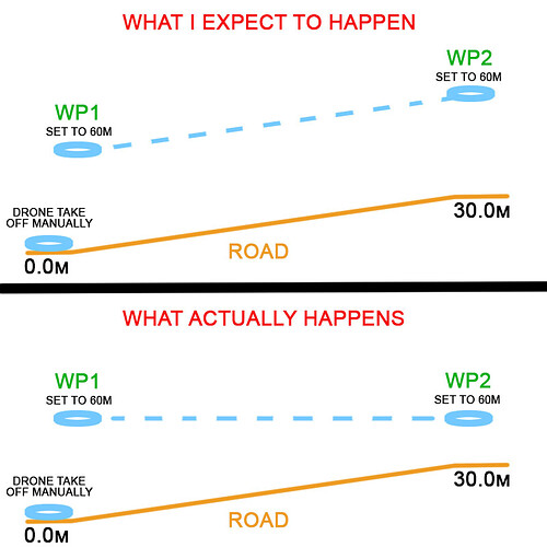
So the GE in my area is 244m. I cant set my waypoint to 30m high as that adds to the 244m. I can only set to -200 which then leaves the waypoint at a lowest point on 44m…
For your drone ground elevation (level) at the take off point is ALWAYS 0 (zero), regardless of where it is on this planet.
The altitudes of ALL waypoints are relative to this (zero).
That’s why it is important that you place WP1 as close as possible to the take off point.
Then if you check the ‘above ground’ checkbox, the value in brackets (??m above/below first waypoint) will be added to the programmed altitude(s) of the corresponding waypoint(s).
NOT the actual ‘Ground Level’ of 224.2m.
ALL altitudes are relative to the take off point, which is ALWAYS 0 (zero).
There are a number of flaws in what you are saying and doing. What Yordie says is correct. However, I want to address a few things you said and try to help point you in the right direction.
While exporting a KML 3D path from Litchi and loading that into Google Earth Pro will work, a much easier way would be to use “Virtual Litchi Mission” which automates those steps while providing even more functionality. If you are not familiar with Virtual Litchi Mission, do some searches. You will find a lot of information about it.
While it may be possible that elevation data for some areas of the globe is not available, it is unlikely, and I have never come across any.
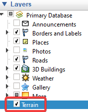
This is because you do not have the “Terrain” checkbox checked in Google Earth Pro. I can see from the snapshot you included the box is not checked. As a result, Google Earth Pro is showing satellite imagery without any elevation data. You need to check the “Terrain” checkbox as shown here:
If you tried to fly a mission with a waypoint set to -200, your drone would try to descend below ground (but would probably be prevented from doing so due to its landing protection).
Litchi doesn’t have elevation data. Litchi uses Google’s elevation data.
To summarize:
All heights are relative to the take-off height unless you have the “Above Ground” option checked. If you are flying in a relatively flat area, simplify things for yourself and leave that unchecked.
Litchi uses the same elevation data that is used in Google Earth Pro – Google’s elevation data.
If you want Google Earth Pro to show proper terrain heights, check the “Terrain” checkbox.
Use Virtual Litchi Mission to help plan your flights.
The drone will always fly to WP1 at the altitude relative to the take off point regardless wether ‘above ground’ at WP1 is checked or not.
The value in brackets at WP1 is ALWAYS zero.