Using Litchi you can’t. A hint would be there’s no mention of such functionality in the online user guide.
Also I’m pretty sure no other 3rd party App has this because DJI has not incorporated such in their SDK.
Using Litchi you can’t. A hint would be there’s no mention of such functionality in the online user guide.
Also I’m pretty sure no other 3rd party App has this because DJI has not incorporated such in their SDK.
Do you have any insight as to why they would not include it. The DJI App seems to fall way short of so many other function, such waypoints etc.
Perhaps, DJI will be coming out with their own advanced FLY APP, that would require it to be purchased instead of giving it away with the drone, while keeping it compatible with the smaller drones, such as the Mavic Mini 2.
I guess only time will tell, because the this technology is progressing at a very rapid rate it seems.
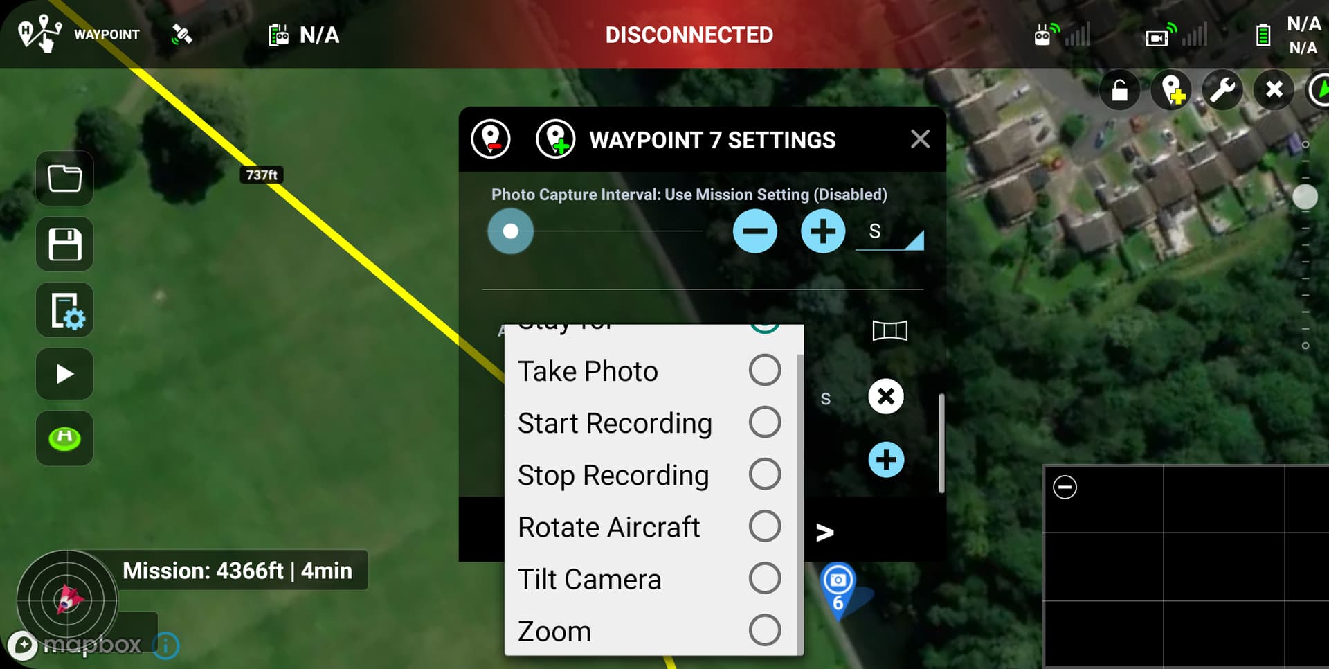
“Zoom in” setting is in waypoints
Please, do not leave me suspense.  , Pray tell friend as I am still very new to this whole thing.
This would be very helpful! Would it be to much to ask if, or would you be willing to, include a screen capture where it is located? In the Mission Hub, or on app? Thanks!
in the app its available for straight line missions as an action at a waypoint, however it isn’t in the mission hub
Thanks, I never use the app to plan… wonder why things are so different, normally it seems it is the other way around. The web has more than the app. Oh well. Maybe I’ll see if my fingers will make it work.
IOS does not seem to have that option, either in photo or video modes. It stops at tilt camera either in straight line or curved, function is NA
In the Litchi setup is there a penalty for setting the minimum location accuracy to a small value, such as 1 meter. ? In my location I need it to be very accurate.
With a setting of 1m, follow will never work for you
I understand that, however I am not looking for the drone to follow me. What I am trying to achieve is a more accurate placing of the drone when it returns to either home point or when it set to land at the end of its mission. I was hoping this setting would assist in controlling that part of the flight. I was set to 10 meters and my drone almost landed a 20 feet from where it was supposed to land. I have over 20 sats for GPS referencing. I found that disappointing.
GPS accuracy does not affect other modes.
The drone also makes mistakes not only with landing, but also with the coordinates of waypoints.
Telemetry can be overlaid on any video recorded using litchi.

Thank you paxxa, yes I am aware, and I also export the telemetry from the embedded cc track to a file and then edit it, and re-introduce it to my final video using Adobe’s Premiere Pro in places where I want it to appear, much like what you appear to be doing too.  . It works very well.
No. I am doing this from a litchi csv file
I’ve got a piece of software called telemetry overlay that utilises data from the drones video feed and also the csv from airdata, which can show all sorts of gauges
I am running the trial version of it, based on your mentioning it. Very impressive, a little on the expensive side, but looks good.
Thanks for that heads up.
It’s a great piece of software, I use it with drone and cycling videos
dashware program. It’s free.