Please share ALL specs of your phone ?!
Galaxy tab 7FE, LG V50, and Galaxy fold Z2
Consider to buy a €10.000 phone. Just joking, but to my experience (with 4 drones in 5 years) drone-apps on mobiles are just a guess. Several specialist say they have no problem, but so many non-specialists have numerous problems. And no solutions.
I’m not a specialist, I just fly a mini 2 for fun, mainly using another 3rd party app at the moment as it has way more options (subsequently cost a bit more as well)
Reading comprehension is not for everyone.
2 Likes
The real solution to track Mode with mini is Buy a mini 3 and use djifly…
I can do everything I need to do with a mini2 (including Track) with 3rd party software such as litchi for a darn sight less than the price of an over hyped mini 3
Ok, so I got both Track and Follow working with the help of Litchi email support.
The reason that Track was not working as it should is due to a software bug that causes the zoom to automatically go to 2X when Track is initiated if you’re recording in anything less than 4K. This is not supposed to happen, Litchi is aware of this and it will be fixed in a future release. A temporary work around is to hold the fn button and use the left finger wheel to zoom back to 1X. Then it worked great for me.
The Follow mode still wouldn’t work even though I had read the manual and watched every tutorial I could find. Location services was on and shared but still wouldn’t work. I noticed that when I hit the button “Set to aircraft position” the height would update to current but the distance would stay at default, this was an indication that my phone wasn’t actually sharing location with Litchi even though it was set to. What finally worked for me was to disable location services on my phone, reboot the phone then re-enable location services.
Hope this helps someone else!
3 Likes
This would explain why I have no problem with either, as I always film in 4K
I stopped “Reading comprehension” somewhere around 1980. I then started my carriere as IA-specialist (industrial automation, machines, factories, robots, plc’s (programmable logical controllers), scada (supervisory control and data aquisition systems) including financial calculations, planning, responsibility and more. All (!) customers always complainted Afterwards (!) they had ment “something else”. Nobody ever wanted to sign for any technical contracttext they expected as result on forehand. To Not think and to Not realise is the new standard since ie 1990. In the Netherlands there are no technicians left (really) and the other 99% are optiMists. But “mis” means “wrong”, which they also deny.
Great that you found these bugs and share the workarounds ! And so special that Litchi responded to you in private !
@Litchi :
- “Litchi is aware of this and it will be fixed in a future release.” Since when1 and when2 ? So many people are complaining at this Litchi- and at the DJI-forum. Every one of them might be a non-customer now if you “are aware of this” but don’t ever respond at the forum and don’t publish ie an “Attention” message. Euuhhh …
- “that my phone wasn’t actually sharing location with Litchi even though it was set to.” How can this be ? The Litchi-app (so the app Itself) always shows there are plenty of satellites connected. Even far more then the 12 max (of the Global 24 in total) that are at any (your) side of any (your) globe anytime. I reboot my phone every few days, regardless of using Litchi or not. That never made any difference to Track Not Function.
Here you go
So why are you still harping on about it?
2 Likes
Alcatel 1S 2020 Specs:
GPS Yes, with A-GPS
NO mention of other GNSS systems.
"With RTH my Mini 2 always lands within 30cms of the takeoff location."*
Has NOTHING to do with GPS accuary of the smart device.
“Litchi and Fly always count more then 12 satellites, even 16 or 18 or 22. Which is impossible”
The Mini-2 uses GPS+GLONASS+GALILEO GNSS-Satellites (24+24+24=72 Satellites total)
“my real outdoor-gps has a screen to inform on 12 sattelites exactly (only), no more.”
Garmin Montana 680 with 6 bars (GPS-GNNS) & 23 visible satelites:
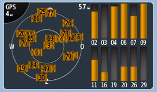
“since there are 24 satellites in total”
The GPS space segment consists of a constellation of satellites transmitting radio signals to users. The United States is committed to maintaining the availability of at least 24 operational GPS satellites, 95% of the time.
To ensure this commitment, the U.S. Space Force has been flying 31 operational GPS satellites for well over a decade.
-BeiDou, or BDS, is a global GNSS owned and operated by the People’s Republic of China. BDS was formally commissioned in 2020. The operational system consists of 35 satellites. BDS was previously called Compass.
-Galileo is a global GNSS owned and operated by the European Union. The EU declared the start of Galileo Initial Services in 2016 and plans to complete the system of 24+ satellites in 2021.
-GLONASS (Globalnaya Navigazionnaya Sputnikovaya Sistema, or Global Navigation Satellite System) is a global GNSS owned and operated by the Russian Federation. The fully operational system consists of 24+ satellites.
-IRNSS is a regional GNSS owned and operated by the Government of India. IRNSS is an autonomous system designed to cover the Indian region and 1500 km around the Indian mainland. The system consists of 7 satellites. In 2016, India renamed IRNSS as the Navigation Indian Constellation (NavIC, meaning “sailor” or “navigator”).
-QZSS is a regional GNSS owned by the Government of Japan and operated by QZS System Service Inc. (QSS). QZSS complements GPS to improve coverage in East Asia and Oceania. Japan declared the official start of QZSS services in 2018 with 4 operational satellites, and plans to expand the constellation to 7 satellites by 2023 for autonomous capability.
That’s a total of 94+ other GPS Satellites.
https://www.gps.gov/systems/gnss/
You continiously mix up GPS accuracy of the drone and the smart device.
“The text of the second link is a joke.”
It’s reality and proves the used smart device’s GPS accuracy is not up to the task (GPS-GNSS only).
“So you are advised to Increase the default 10 meters to ie 20 meters Minimum accuray to solve issues”
That’s YOUR conclusion, and nowhere written.
“It seems to me that Litchi messes up the Maximum and Minimum accuracy. Max-Accuracy is ofcourse a smaller absolute number (so with Less Tolerance) then Min-A.”
No, You are messing it up.
Again: Reading comprehension is not for everyone.
“I stopped “Reading comprehension” somewhere around 1980.”
“All (!) customers always complainted Afterwards (!) they had ment “something else”.”
In other words: You never comprehended what they really ment.
3 Likes
“So why are you still harping on about it?” I am not harping, and this is why :
1- People pay for an app that doesn’t function concerning 2 main functions.
2- Litchi Knows About That !!! For a long time already.
3- Litchi does not solve the problems.
4- Litchi does accept the payments.
Qutes from the reply of Mark Sanders :
- Got Track and Follow working with the help of Litchi email support.
- Due to a software bug.
- Litchi is aware of this and it will be fixed in a future release.
- The Follow mode still wouldn’t work.
- I noticed that when I hit the button “Set to aircraft position”.
- What finally worked [for me] was to disable location services on my phone, reboot the phone then re-enable location services.
- Hope this helps someone else!
I really hope so to !!! And I hope you remember this very carefully for the moment ie your car refuses to function (after you payed that bill). Then this way of “solving” and (principal) workarounds might help you to ! Without refund that is.
The Mini 2 is a 2020 design and the multiple gps-chips came available only later. Please let us know the exact type of the Mini 2 gnss-chip.
There are multi-GNSS receiver chips available but they handle max 2 systems simultaniuosly, not three, let alone more. Besides that they handle 32 channels max in total (GPS, GLONASS, Galileo, QZSS, SBAS).
Garmin : which satellite systems should I use ?
Sats In Operation : GPS = 30, GLONASS = 23, GALILEO = 22. Two systems is the max (since 2022) per device and 50% Is At Your Horizon (select All objects illuminated by the sun). So you could have ie 27 or ie 26 or ie 13 sats avaiable. No more.
GLONASS constellation status :
https://www.glonass-iac.ru/en/sostavOG/
There are 22 sats in operation and 50% Is At Your Horizon.
Galileo sats status :
https://www.gsc-europa.eu/system-service-status/constellation-information
“Once fully deployed, the constellation will consist of 24 operational satellites with 6 in-orbit spares.” Only 23 are operating today, so 11 at your horizon.
GPS: The Global Positioning System :
https://www.gps.gov/systems/gnss/
Official U.S. government information about the Global Positioning System (GPS) and related topics. Interessting info concerning other gps-systems available.
BeiDou Navigation Satellite System :
http://en.beidou.gov.cn/SYSTEMS/Monitoringandevaluation/202206/t20220618_24280.html
The number of visible Beidou bds-sats seems to be 12 to 14.
Live Map of Satellite Positions :
Select GPS or Glonass or Galileo or max 2 of them and see what happens (not).
The trick with technical (!) data and info is to analyse it, not to hype it up to any preferred max.
I lost my Mini 2 drone 2 weeks ago due to what I think was a batteryfailure. I got an unexpected rth-alarm at 36% charge already and it drowned to 3% within 1 minute. It actually only wanted to fly (fall) down, not horizontally anymore. I managed to fly it in my direction from some 400 meters until it was only some 50 meters away (according the app). Then it lost contact and (so) the find-function didn’t function either anymore. I searched for it for about 1 hour and once more the next day but I didn’t find it. Some days after I dumped the controller plus the sparebatteries and spareparts. That was all folks !