The location button doesn’t work.
Thanks, I’m exploring options for this.
What device/browser are you using? It’s working on my PC and mobile. You might have to give permission to activate GPS
At the moment all it does is get the GPS location and move the view to this location one time. It doesn’t continue to track the location afterwards and doesn’t remain ‘active’.
I plan to automatically add the home point when the user presses the button to help people who are standing outside ready to fly.
hey ! Nice tool keep it up!
Is there a tool that combines the photos into one picture? Similar to 360 degree panorama only as an aerial view
Thanks
Thanks Heiko,
Yes what you’re talking about is called an orthomosaic.
There’s an open source solution called ODM which can be used either by command line or using a GUI if you install WebODM.
It’s a little bit tricky to install for non-programmers unless you want to pay for the easy installer but it’s a great start for beginning photogrammetry.
4 Likes
Hi James !
Thanks for this useful app that should be implemented in Litchi since years… One feature I would love to see is to be able to import a shape (kml, shape file or even csv) instead of having to draw the polygon. Even just a way to display a polygon, and then have to trace on top of it, would be enough. This would allow your app to be the “missing link” between QGIS (or other GIS) and Litchi.
No idea if it’s hard to do or not, and I’m quite sure you thought about it already, but who knows 
Thank you again for your work, keep on going it’s great !
3 Likes
Thanks Jeremie, I’m working on it right now Also probably going to include address search to speed navigation up!
1 Like
I just pushed a little update that unlocks a much lower GSD option of 0.1 (some drones can fly as low as 2.3m or 7.5ft) and a much lower speed (0.1m/s or 0.3ft/s. A user requested this feature and I think it’s good for small scale photogrammetry. Be careful not to draw a big polygon and set the GSD value to 0.1 as it will draw a lot of objects on your device and will slow the app down until there are safety rails built in. Zoom has been increased to cater for smaller areas.
Photo footprint rectangles are set to off by default now as I’m seeing many mobile users. Rendering many rectangles slows the app down on my phone so it’s probably best to have it toggled.
My next task is to allow for kml, csv, text and json/geojson ‘upload’. This will read the file you load into the browser and draw the area of interest for you. I just want to say that everything is client-side only so I never see your GPS data or the areas of interest that you upload.
Additionally, it was mentioned that the P3 can’t take photos with distance intervals, so I will also be creating a toggle between photos by distance and photos by time.
There are still some of the original bugs that are getting on my nerves and I plan to squash them when a friend returns from holiday and alleviates me from his hounds!
2 Likes
Hi James
Thank you for designing this. I checked in this morning and see the addition of the photo footprints.Really nice, thank you.
I have some issues that I hope you can help with.
Litchi seems to only allow 99 waypoints .
It does say that it will stop the mission after 99 and upload the balance of waypoints. Only each time it fails to up[load with a message that the waypoints are too close together. This is not the case…
Secondly I am finding that the drone stops at each waypoint to take the photo. Is there a setting that will allow the drone to continue on its path and take the photos on th erun?
regards
and t hank you for this program.
Tony
Hi shellant,
I thought Litchi lifted the waypoints limitation to 5000, but I could be wrong. I think I remember flying a mission that went beyond 99.
Could you estimate for me how close the points actually were to each other?
There’s a bug in the procedure at the moment that can sometimes create such a predicament, here’s an example to explain:
The line is 100.5m long
You generate points every 20 metres
A point gets placed at 100th metre and also at the end of the line, making those points 0.5m apart and unable to be flown.
I think this is probably the highest priority bug for me right now just because it’s based on probability and also it’s generally not noticed until the app won’t fly the mission. I’ll work on a compromise now.
It’s happened to me before and I simply deleted one of the points that were too close to each other, but users shouldn’t have to do that so I’ll fix it in code.
About your drone always stopping to take a photo, you can adjust the Z-Check value to compensate. This determines the ratio between photos taken and waypoints generated.
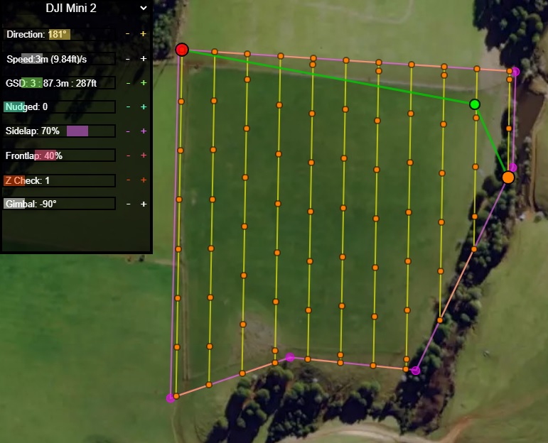
This is Z-Check of 1. A waypoint is generated at every photo location and elevation is adjusted at every photo.
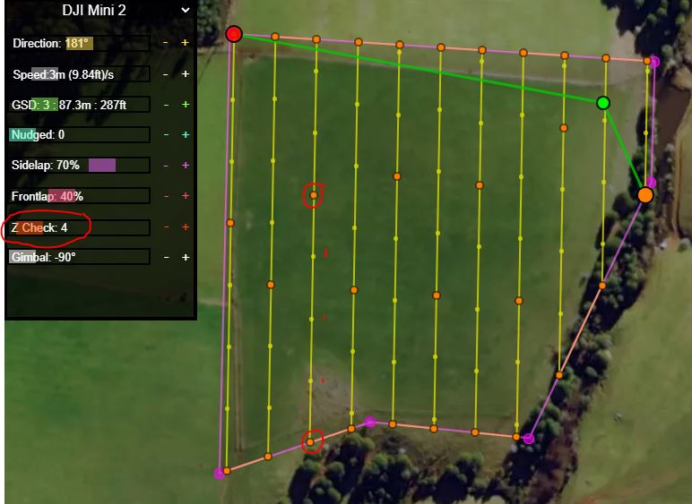
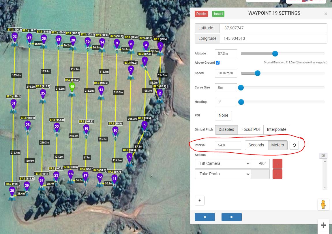
With Z-Check at 4, the waypoints are decimated. The elevation profile is slightly different (more risk in areas of large elevation differences). The drone will take photos on the move between each waypoint, reducing mission time. If you’re in a flat area you can jack the Z-check right up to max and fly end to end to maximize distance.
I can’t think of a better name to call it to describe the things it does for versatility.
2 Likes
Hi James,
I made sure to update to the latest version of Litchi on both my ipad and Iphone and with both I get the message at the beginning of the mission immediately after the mission is uploaded to the drone that it has more than 99 waypoints so will stop at 99 and hover while the next 99 are uploaded. In each instance the upload appears to begin but fails with a message about the points are too close.
I am sorry but I did not copy the exact wording when this happened.
I think I am understanding your question about the distance between the two points.
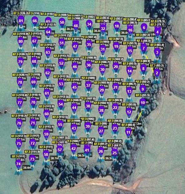
-All points are between 25 feet and 32 feet apart.
-The distance between point 98 and 99 is 32 feet as is the distance between 99 and 100
- I did have a test mission where there would be two points at the end of some of the lines.
but I was able to delete one of these in litchi .
I can send you a screenshot of the latest mission to see if you think I may have done something incorrectly.
Thank you for the tip on Z-Check value helping to keep flying while taking pictures .
Unfortunately I won’t be able to test until the weekend but will try to before
Regards
Tony
Also out of curiosity which drone are you flying? I’ll be doing some tests myself again but have a bout of heavy rain at the moment.
-JDR
Hello, James!
I have been watching your work since the first days of publication on the forum! You did a great job, you did a good job. I somehow did not write anything, hoping that the Litchi would soon implement these functions into the Litchi program, but alas, the guys are in no hurry and this is very upsetting.
And now I will still speak out about your work (what is missing, and I suggest you pay attention to it).
- The function of the possibility of fully stopping the drone before taking pictures and after (Stay For) is missing.
- The function of dividing the route into conditionally any number (Split route) is missing, It is extremely necessary!!!
- The function of saving routes on the server (or on the computer with subsequent loading back into the program, for editing, correction) is missing.
Thank you very much for your work, and I hope for your feedback and understanding of the pilots’ wishes!
Sincerely, Magomed Abdulaev Dagestan.
2 Likes
Hi James
I fly a Phantom 4 pro.
Also could I ask if there is a way / or you could adjust the photo footprint button overlay to be a bit more visible. I have adjusted my screen but I still have difficulty seeing the overlaps.
Regards
Tony.
2 Likes
Thanks for the kind words and suggestions, Magomed!
Hopefully this app can help to fill the gap for most people and in future perhaps become a generalized web-app if Litchi wish to integrate their own solution.
-
This is a good suggestion, I thought maybe having Z-Check set to 1 would be good enough to prevent motion blur but some people might need more stability.
-
After reading @shellant’s comments it seems as if older models like P3 and P4 have legacy limitations that must be catered to. Exporting multiple files would be challenging for the approach I have taken thus far but these models seem unable to process more than 99 waypoints. I think I have a solution in my mind.
-
I think this is a good idea too and will for now try to implement it client-side. We can download a json file and reload to recreate the polygon and settings we had. If a server is ever needed for multi-device user experience it will be a natural progression. Cloud storage would be a wise place for a user to save their files.
I’ll keep chipping away at the needs of everyone and try to keep the interface tidy.
2 Likes
Thanks Tony,
The photo overlay was subtle because there wasn’t a way to toggle it originally. I’ll experiment soon to improve visibility, maybe slightly randomise the colours to help the eye separate each section.
We have to remember that due to consumer grade GPS accuracy, these footprints have a tendency to float around so they’re really only there to help the user see the level of connectivity between each photo.
Address search has been added!
More features to come soon.
3 Likes
Wonderful!!!
Thank you very much friend. We are looking forward to it.
Sincerely, Magomed.
1 Like
Z-Check подробней можете объяснить для чего ?
1 Like