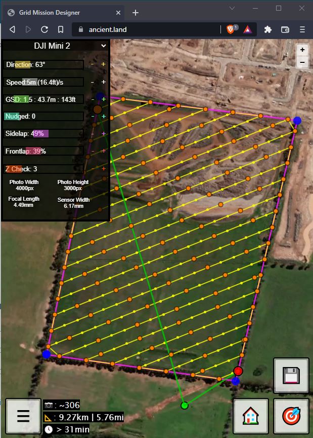
Here’s a quick video explaining what it can do and how to start using it:
It’s in beta, there’s a few bugs to squash and there might be some issues with the specifications set for each drone so if you notice any issues or have any suggestions let me know!
Also the estimated time can be way off so be conservative until I improve the calculations.
Please try it with a simple and low risk flight before attempting more complex missions!
Current Issues:
Line gets flipped at cardinal directions (0, 90, 180, 270)
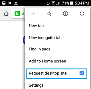
OK. Let’s go here. Here I have a litchi app, I created a mission with your tool, and downloaded the csv file to my phone. and in order to make a mission for litchi out of it, I need to download this file to my laptop, import this csv file into the mission hub, then save it as a mission. Too much action don’t you think?
Ahh okay yes I thought you might be talking about the vertices. Actually I wanted to keep the graphics simple enough for mobile and not have too many buttons like delete vertex. For now we can only redraw the polygon. Apologies for the inconvenience.
You will also find such errors as when a concave polygon is drawn, the lines do not work properly on some angles. My algorithm is not perfect but it works okay with convex polygons
Another limitation is that I have not written the algorithm to accommodate for complex polygons. It is currently too much work for the small crowd who needs such shapes.
I think if the user needs to clear something, it means they are going to draw again anyway. But I see that it can be frustrating when the points block your vision as you redraw. As the interface improves, a clear button might be added. Maybe people will become annoyed when they accidentally press the clear button on mobile.
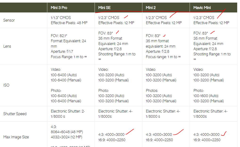
mini, mini se and mini 2 actually all have basically the same cameras, so I’ll rejig a few things to make it more clear. If you take it for a test, find a flatish area and set your frontlap and sidelap to 50% and optically confirm that your photo intervals approximately reflect those values
Very good tool, James. Thank you very much. Suits my purposes, principally. Can you or somebody else recommend a selection of drone model that comes nearest to a phantom 3 standard. I’m still using this old modell. Otherwise I could do some testing to find out proper side and frontlap settings.
Thanks Rainer, I just looked up the camera specs for the Phantom 3 variants and added it onto the list.
It would be nice if you could test some sidelap/frontlap value just to make sure everything’s okay.
I can’t recommend a particular model. It seems we are quite spoiled for choice! Certainly a bigger camera sensor is desirable.
Greetings!. Is there a way to navigate the map using a search by location/name input so you can immediately go to a specific location on the map?
Also a map overlay showing the name of streets or area similar to Google?
I can’t figure out a way how to locate a place to draw a waypoint from the default displayed map without having to manually zoom in and pan but then it’s quite a pain to go to a specific location without any aid or guide. It forces me to open Google Map and compare side to side in order for me to be where I want to create the WP. Appreciate the effort in creating the app by the way. I’m in the Philippines. Thanks.
At the moment there’s no ‘hybrid satellite’ showing street names etc. I understand the frustrations of not being able to navigate freely.
Before settling on a map service that includes such things, I’ll make a GPS zoom function you can press to take you to your current location. Developing with Google map services isn’t as pleasant as using Google maps at this point in time.
Geolocation button added. I don’t track any locations and respect everybody’s privacy
The buttons have shrunken slightly, let me know if they’re too small. In future I will redesign the pop-up menu so be more friendly on both desktop and mobile.