Since introduction to this fancy new user interface, basic functionality has gone to HELL !!! Simulated flight in the new interface, and KML flight exported in the old interface both are dozens of meters too low. Adjusting flight above 1st waypoint vs flight above ground has not affect!!!
Software devs (a.k.a. code monkeys), if it is working don’t fix it! You broke one of the best features of litchi (3-d simulation of flight). I’m not on a beta channel, for the exact reason that I didn’t want to end up in this situation, but finally it was forced onto me. This is a deal breaker, I’m ready to drop this app.
The new Hub is still in beta, which is why I’ve moved your post to the correct category. If you’d like us to help troubleshoot your issue, we’ll need more details to properly understand what’s happening. Simply blaming the developers won’t get us closer to a fix. Could you please share specifics such as your exact workflow, platform, app version, and an example mission file? That way we can try to reproduce the problem and provide a solution.
3D flight is now integrated into the new hub, be sure to check out all the new features.
That is kind of harsh! Most people, including me, think the Flight Hub v2 is a vast improvement over Flight Hub v1. Many new features have been added and many are still in the works.
Both the new flight simulator and the old export of a KML file to Google Earth Pro are working fine for me. You will need to provide more information for anyone to help figure out what you are doing wrong of if indeed you have uncovered a bug. The original Mission Hub v1 has not been changed. So, if you are experiencing a problem with the older Virtual Litchi Mission application, perhaps you have something incorrectly configured in Google Earth Pro.
Depending on the terrain where you are flying, this might be normal. Again, more information is needed to troubleshoot what you are describing.
You are again being very disrespectful. The old Mission Hub v1 is still available. It has not been “fixed”. At this point no one is being forced to use the new Mission Hub v2. Also, it is odd to suggest that software should not be improved. Unless software is continuously improved, it will fall behind other similar software offerings.
This is probably good. To be a useful beta tester, one needs to provide constructive feedback offering clear instructions on how a potential problem can be repeated. This way, the software developers can follow your steps and either confirm the problem or suggest a different way to accomplish your task.
I’m not having any issues as well running a 50’ AGL path. If it’s the altitude indicated on the preview it is always based on ATL. So It could display an altitude higher or lower than the set AGL altitude because the altitude is always referenced from take-off, ATL. I’ve flown a lot of AGL missions over the years and no problems. The new 3D mission preview looks like it’s reporting the correct altitudes on my mission plan. Just a thought. Enjoy.
As many of you have suggested, I’m posting more details about my issue. The reason I believe it’s a software bug is that I’ve been using Litchi for 5 years and have NEVER encountered this issue, until the introduction of “The Next Generation Litchi Hub”. Now I’m having the same problem with the old and also the new “next generation” hub. Coincidence?
Even more why it smells like shoddy software is that occasionally, after reloading the mission, the altitudes do display correctly even though my mission did not change!
I have 4 screenshots to illustrate the issue, but the Litchi code monkeys have limited embedded media (= photos) to only one since I’m a new user. Being a paid user of Litchi since 2020 does not count, it seems. So as much as I would like to include more, I have been constrained to including only one screenshot.
In the OLD litchi view, altitude is OK.
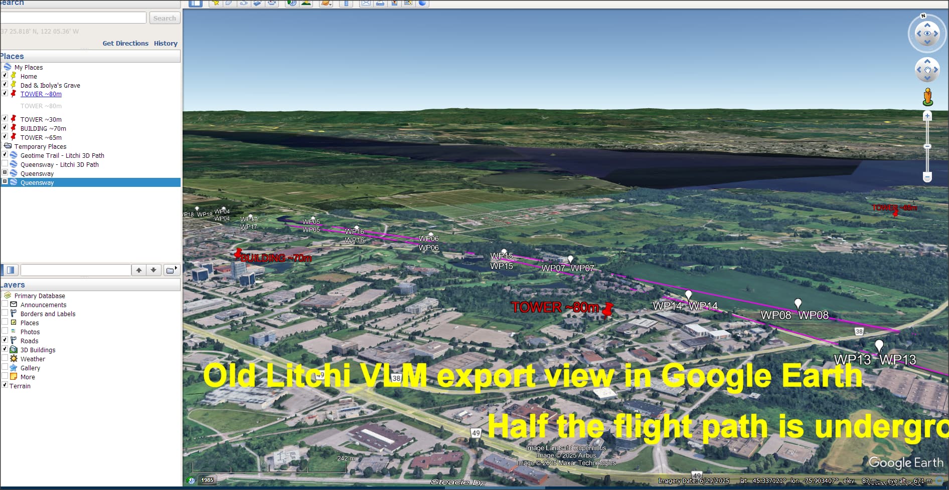
Exporting to VLM from the old Litchi and opening in Google Earth, altitude is incorrectly very low.
Yes, it is probably a coincidence. No one else has reported the same problem. If it were a bug, it would affect everyone. So far, this only appears to be affecting you. I have been unable to duplicate what you describe.
This suggests that it may have something to do with the Google Elevation API quota and the API key being used. The shared Google Elevation account occasionally goes over quota preventing elevation data from being returned from Google. This would explain why simply reloading may or may not result in the lack of elevation data. You would see messages in VLM regarding this.
Being a paid user does count for being able to use the Litchi app. However, it has nothing do to with this forum. In this forum, you must earn the right to post more than one image after joining.
That is enough! I will remind you that in this forum, you must adhere to the forum rules. I would suggest that you re-read them. In part, they say: