Hi Im am planning a flight mission on my A2s with smart controller. Its at 35 min. Will drone auto inform me when battery gets low, and RTH? Then I can pop a new battery in and resume flight at desired waypoint? OR do I need to trim flight down, and create two separate flights?
Bugs found so far with smart controller: first waypoint does not tilt camera at assigned angle? Easy workaround do 2 waypoints at start. Second issue litchi warns me im not in N flight mode, but really I am and I have to toggle it off N into S and back before flight starts.
The drone will definitely RTH the instant its onboard calculations determine that the battery charge capacity will not suffice to complete the mission. I doubt whether returning to base for a quick battery swap will give any extra range since the craft will run an identical battery power calculation each time the same mission is flown.
Regarding camera tilt, my older drones Phantom 3 S, Phantom 3 Pro, Mavic Pro1 and Mavic Pro Platinum require the camera tilt angle to be set manually before the retrieved Litchi waypoint mission is started up because once the craft goes beyond RC signal range, the camera tilt cannot be changed with the rotary wheel on the controller. Also, it helps to disable camera tilt in the Litchi settings so that only the pre-set camera tilt angle is assigned with no conflicting camera angles specified for individual waypoints.
“resume flight at desired waypoint?”
You can start a waypoint mission at any selected waypoint.
“Bugs found so far with smart controller: first waypoint does not tilt camera at assigned angle?”
This is not a bug:
-If two adjacent waypoints have different altitudes/headings/gimbal pitch, then these will gradually change as the aircraft flies between those waypoints.
In other words:
Interpolate needs 2 waypoints to work.
Thanks, I decided to make two missions at 20 min max flight to be sure/safe! Yes I am setting my camera tilt at -20 for forestry viewpoint at every waypoint. I set my first two waypoints at -20 camera tilt, only the second waypoint actually tilts camera.
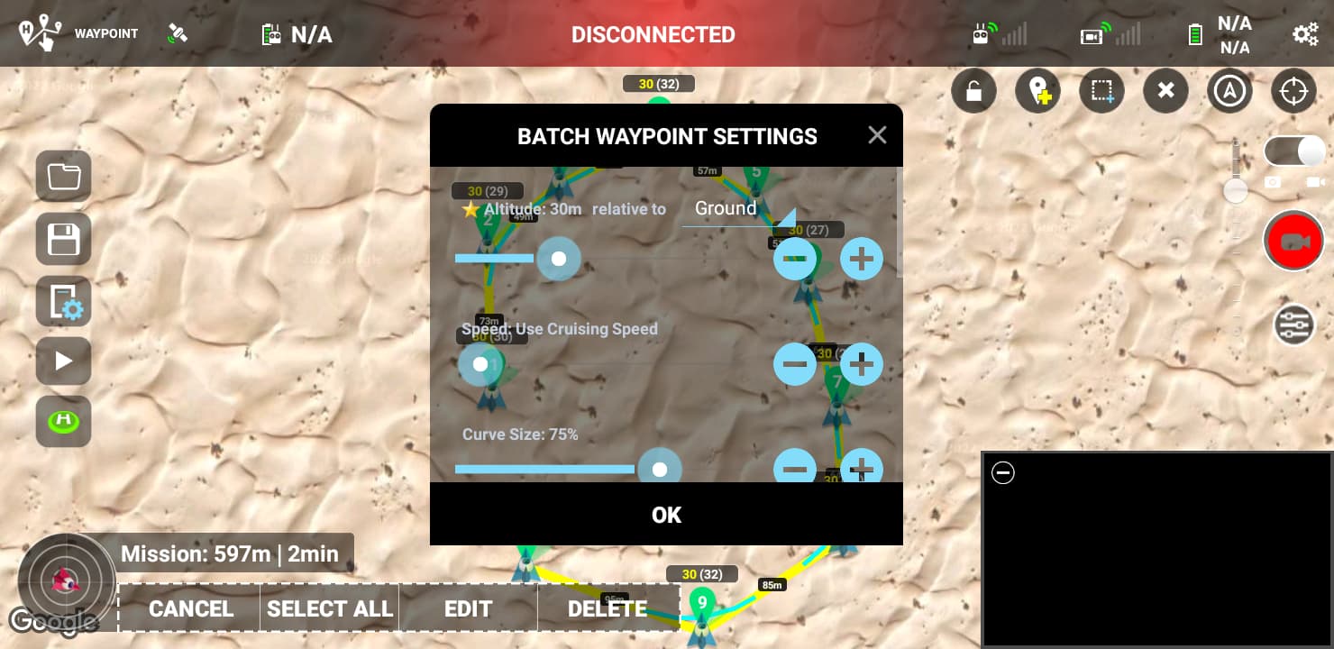
Another question: I see there is an AGL check box. Will this use the GPS elevation or the DEM elevation at time of capture and increase and decrease and drones altitude? I want to maintain an even 200’ above the ground on my entire mission. So I should set my drone altitude at 200 ft and also check the AGL also? If I don’t check this box will the drone just stay at 200’ above my initial takeoff position? I’m confused? My forestry project dips 30-40ft from my starting altitude. I want to maintain a good 200ft above ground at all times. Select the check box or not?
Gotcha, I’m adding a second point right next to point one to get my camera tilt -20 almost instantly
Yes I see the setting to resume mission at desired point. Im going to do a save as, delete my first half of the mission and save it as mission two.
I would suggest that you take a look at the Mission Hub user guide as your questions are answered there. From the manual:
By default waypoint altitudes are relative to the take off point (which is also usually the home point).
If you enable the “Above Ground” option in the waypoint settings, the altitude you enter will be relative to the ground below the waypoint.
The “Above Ground” option can only be enabled if elevation data is available for the waypoint (see Elevation Data section below).
When “Above Ground” is enabled for a waypoint, the waypoint’s icon will show 2 altitudes, the altitude above ground (yellow) and the calculated altitude (white) relative to the take off point which will be the altitude sent to the drone.
Important To calculate these altitudes, it is assumed the first waypoint is in the same location as the take off.
Thanks, I’m going to use AGL and setting use online elevation in mission settings - I’m not sure how accurate the built in elevation data is, but I am flying a forestry block with a camera tilt for video and want to follow the terrain (and tree tops) more than set elevation from takeoff position. I’m giving myself 80-100 feet of DEM error. Then re-fly project after thinning.
Can I switch AGL off for entire flight by de-selecting use online elevation ‘in the field’? incase I’m not happy with it? or is it too late as I have saved AGL for all waypoints at home already?
Inside the Mission Hub you can toggle the “Above Ground” checkbox on and off for any (or all) waypoints. However, doing so does not change the height of the waypoint. It only changes the AGL display for each waypoint.
This option is not available in the Litchi app. If it was desired to use this feature in the field, you would need to bring a device capable of running the Mission Hub web application.
An altitude of 150 feet Above Ground Level at each waypoint is my preference when using Mission Hub to plot Litchi autonomous missions. Oddly enough I’d launched well over a thousand cumulative miles of such waypoint missions before I realized that Litchi’s altitude callouts refer to the current height of the drone above the initial home point, and not above the current waypoint being overflown.
That moment of realization was so sudden that when I heard a call-out for “90 feet” during a flight over a low-lying area that I was certain had been specified to cruise at an altitude of 150 feet above each successive waypoint, I panicked and hit the RTH button at the very moment that an intermittent RC signal connection was interrupted for a long stretch.
After considerable nail-biting and visualizations of the drone hovering in place until its battery forced a graceful landing in the middle of a tropical swamp, the angry-bee tone of my trusty Phantom3 fading in from the distance, reassured me that my bumbling RTH command did not result in calamity.