I have used the Scot Murray app to configure a Vertical circle. When I import it into Litchi mission hub the waypoints appear but the map doesn’t it says Elevation Data Missing. when i import it into DRONELINK it works perfectly. I’m wondering now, which is the better software.
DJI Mini 3 Pro-RC N1
David,
I havent been able to reproduce your error. I get the line of waypoints and a map displayed in the Hub.
The model of drone does not matter when importing a KML file into the Mission Hub.
The choice of software you use is obviously up to you.
If you would give more details about your workflow, that could help someone resolve your problem.
Sam, this is the workflow, as you can see no map
You checked the “Treat views as waypoints” option. Does your kml file have “Placemarks”? You may need to share your kml file to get the answer you are looking for.
Although you’re not realy asking any question, in my opinion the answer is right in front of you:

-Did you enable Online Elevation in the settings ?
-Did you read the provided link “help#missionhub” ?
Hi Sam, this is the KML file
I think Ive found the problem, for some reason it keeps placing the KML file in the Indian Ocean
That is not a KML file. It is an HTML file with a lot of embedded JavaScript code.
looks like i’ll just use dronelink then
It imports correctly into Litchi, even if it has embedded JavaScript code.
Here is another example, if you want to have a look at it.
Initially, I directly saved that link as a KML file. However, that link is actually pointing to OneDrive with download button for your KML file. That was my mistake.
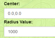
Your KML file is valid. However, the Latitude/Longitude coordinates in your file are all around 0,0. That will place this mission off the west coast of Africa in the Atlantic Ocean. Scott Murray’s application requires you to enter valid coordinates for the center of the circle. Leaving them at 0,0 will place the circle at Latitude=0, Longitude=0. Here is your first coordinate:
0,0,160
That is a GPS coordinate of 0,0 with a height of 160 meters.
The Placemark element in this file does not contain any viewing parameters. Therefore, checking the “Treat Views as Waypoints” checkbox will have no effect.
Hi Sam, many thanks your help, I now have it sorted.
1 Like