Just a question, about track coloring, do you have any idea of how airdata manages to colour their tracks by ENERGY USE?
i’ve found that very useful, in some cases, to analyze how much effort the drone was making to keep desired speeds (and, by inference, the wind against it in those moments), but i’ve never got to see how they derived that from the logs.
It’s such a particular view of the flights, that i’ve downloaded every single kml with that colouring:
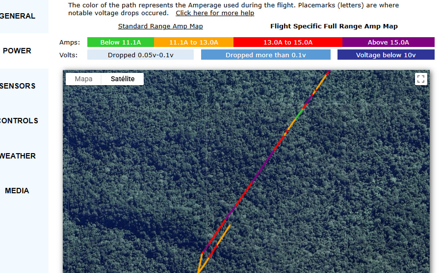
Voltage and Ampere both are tracked and available in the telemetry section, you can turn on map sync and play the telemetry in sync to the flight path.
About the binaries, I am not sure what’s happening, because I can see it in the test builds. Did you try from the latest tag or the nightly one? I will rebuild them and hopefully it will be live.
1 Like
Please re-download from the latest release and give it a try! I have re-build them from the latest commit.
1 Like
Hi Arpan, where can i find the README
Hello @Martin_Reading
Check out the Github page link for the readme.
1 Like
Many thanks, had a quick look and requested my data from Airdata, looking very promising ![]()
Well I got all my data imported, and very impressed, so will be buying you a coffee ![]() , I’ve one little ask though, though I’ve got my distance in feet, and speed in mph, would it please be possible to have temperature in Celsius, even though I’m English and 67,Celsius means more to me than Fahrenheit
, I’ve one little ask though, though I’ve got my distance in feet, and speed in mph, would it please be possible to have temperature in Celsius, even though I’m English and 67,Celsius means more to me than Fahrenheit![]()
Done in version 2.30.0 on GitHub (latest release)
Let me know if that works perfectly for your needs.
Would appreciate your support a lot ![]() Thanks a lot in advance.
Thanks a lot in advance.