Same problem here. When you try to fly a virtual mission, its burrowing underground.
And when you check Waypoint info in the Diagnostics of Google Earth Pro, it shows the wrong altitude.
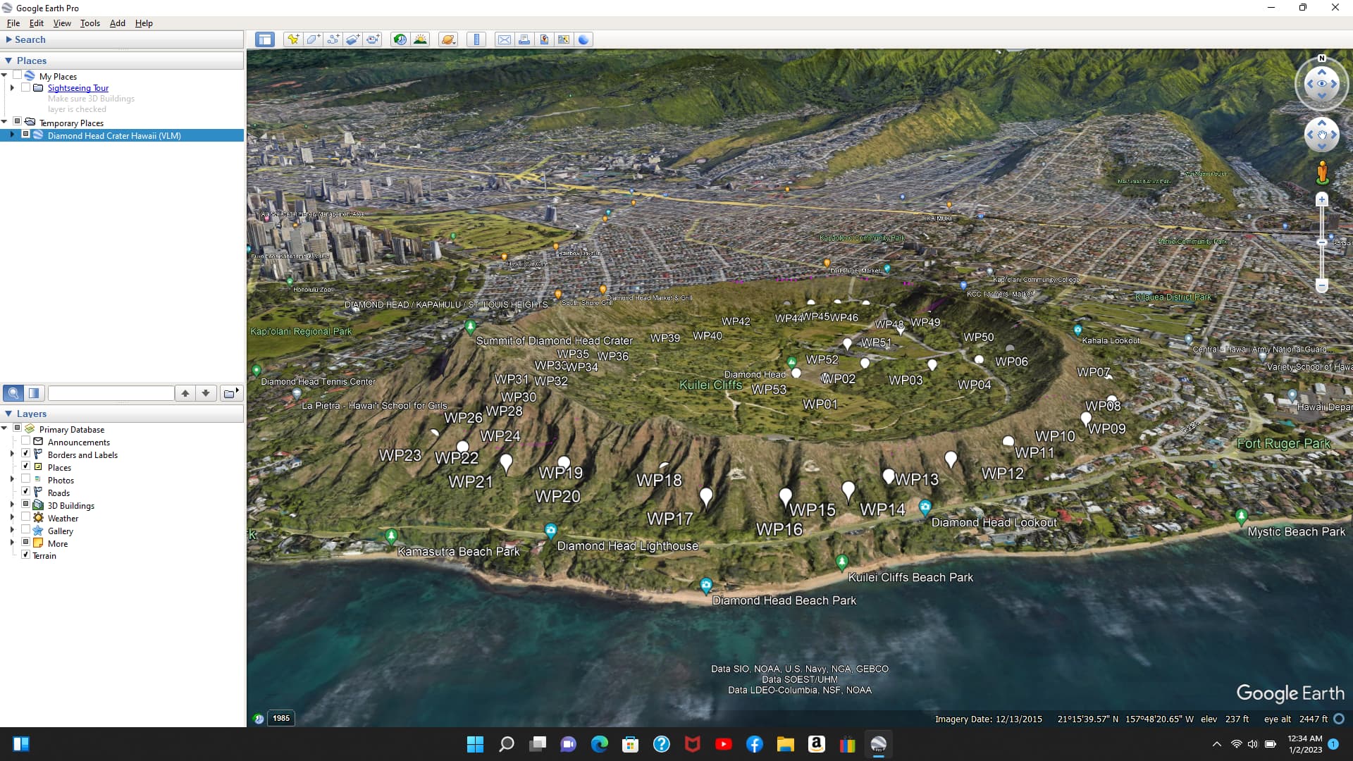
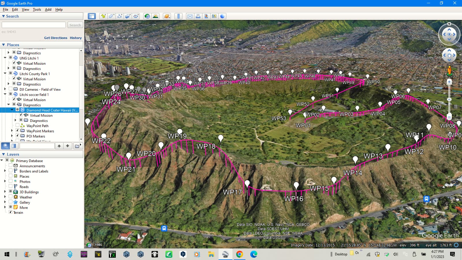
This is very odd! Both of these images were taken today, but the bottom screenshot was taken today using my old HP Laptop while the top screenshot was taken with my new Laptop a few minutes later. I was wondering what might be wrong with my settings but now I am wondering why a Google Earth bug would only affect one computer and not the other. Both computers are using the same version of G.E. which is 7.3.6.9326 64 bit.
@Andrew_Bennett, is this happening on the same computer? I have been checking with the VLM section of the MavicPilots and all they have said so far is to check FOV in Google Earth, and to check the Settings next to the mission in GE. I have heard nothing that would explain the Altitude difference or why the VLM works on my older HP Laptop with Windows 10, but NOT on my newer HP Laptop using Windows 11. The FOV and other settings are the SAME as far as I can tell. Virtual Litchi Mission | DJI Mavic, Air & Mini Drone Community
I’m also having this issue. Just started today. It has to be something in VLM, as i can pull up virtual missions that were generated in the past and they look fine. Nothing changed on my end recently, litchi or the VLM portion of Litchi had to have been updated.
Edition Windows 11 Home
Version 22H2
Installed on 10/13/2022
OS build 22621.963
Experience Windows Feature Experience Pack 1000.22638.1000.0
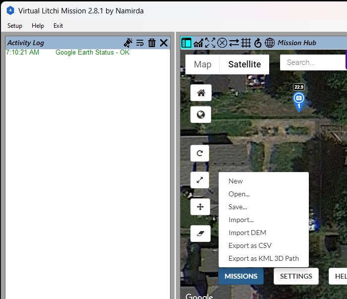
As a test right now using a different mission, if I use the Missions Export as KML 3D Path option, the download text file altitude values are correct and looks right in Google Earth Pro …
It appears that VLM isn’t taking the ASL altitude into consideration (i want 30m, but my takeoff point is 200m ASL, so it needs 230, but is sending 30)
I don’t think anyone here has made it clear which version of VLM is producing this error.
I use the VLM Windows application written by Namirda. It is still properly sending flight paths with the correct elevation to Google Earth Pro for me.
There is also a Chrome and Firefox VLM extension which is a different piece of software than the VLM Windows application. It was written by someone else.
When you say VLM has a bug, you should make it clear which VLM you are referring to. Either the browser extension or the Windows application.
namirda agrees with you and I have the Chrome Browser Extension that he can’t do anything about. What is strange is I have exactly the same versions and settings but only one is screwing up. namirda said:
I think we are possibly mixing things up here. “Export as VLM” is an option in “Chrome Litchi Virtual Mission” which is a Chrome Extension offering similar functionality to VLM. The Chrome extension was developed later and separately from VLM and the source code is different.
It is the windows application called Virtual Litchi Mission (VLM) which is the subject of this thread.
My apologies for not being specific as I’m brand new to this and it’s only been a week since getting my DJI Mini 2 drone, buying the Litchi app for my iPhone and discovering the flylitchi.com web site mission feature, downloading the Chrome extension for the Export as VLM option, getting Google Earth Pro, and learning how to create and visualize missions. I’ve download the Virtual Lichi Mission V2.81.1 software and will look at that tomorrow.
That’s ok. I guess some are not aware that there are two “VLMs”. Namirda created the Virtual Litchi Mission Windows application first. Some time later, another person reverse-engineered what Namirda had done and created a VLM Chrome extension. Unfortunately, both are referred to as “VLM” (Virtual Litchi MIssion), creating some confusion.
The VLM Windows application still works properly. I’ve been using it today. I just tried installing the VLM Chrome extension. I got a flight path underground in Google Earth – same as other people.
I don’t use the VLM Chrome extension, so this is just a guess as to why it is not working properly. The original VLM allows one to enter their own “Google API Key” to access Google’s elevation data. If you do not enter your own API key, VLM uses a shared key that has usage limits. If too many people use VLM in a specified time frame, VLM will no longer have access to Google’s elevation data. To ensure this does not happen, users are free to create their own API key and use it in VLM where they will never hit that usage limit. Perhaps (and this is only a guess), the VLM Chrome extension uses a shared Google API key and with all of the users using it, has exceeded some limit. If this is the case, you can either wait and see if the VLM Chrome extension starts working properly tomorrow or next week, or just install and use the VLM Windows application.
Same here, using Chrome VLC extension on Mac. It was the first time that I tried it since 31st December, when it was still working fine. Now all missions (old and new) exported to VLC are buried down underground :-(. I also tried to use some older VLC/KML files created just one week ago and they are fine. Since I have a Mac, I can’t use the native Windows application and I have to stick to the Chrome extension.
I wrote a small program to analyse the difference in altitude between the original and newer klm files (for a specific mission I still had the originals). The altitude in new files is most of the time 200.5 meters below the original, but not always. Original file (with correct altitude) had camera altitudes between 215.5m and 380.5, in the newer created file it ranges between 15.0m and 180.0m. Difference between both files ranges from 172.7m to 200.5m (but average is 198.8, since most of the time the difference is precisely 200.5m, as stated before). The orography of the flight area ranges between 199m and 320.9m and it seems still correct today in mission hub.
Google Chrome version: Version 108.0.5359.124 (Official Build) (arm64)
Chrome Litchi Virtual Mission: 0.2.1
One more point. I was able to find the original VLC/KML of a flight over sea around a small island. All flight points are above sea level. Compared with the VLC/KML of the same mission extracted today, all altitudes are almost identical (there is a negligible shift of less 1cm). This suggests that the problem is related with VLC not being able to extract topographic information, and that VLM isn’t taking the ASL altitude into consideration :-(, as stated by @Robert_Tek before. This may suggest that the problem may be something like the issue suggested by @wesbarris above (“If you do not enter your own API key, VLM uses a shared key that has usage limits… and the VLM Chrome extension uses a shared Google API key and with all of the users using it, has exceeded some limit”).
Here is the original VLM Chrome/Firefox extension thread from Mavic Pilots:
It appears as though the author of this software has not visited the Mavic Pilots forum since October, 2022. So, I don’t know how well any bug reports will be handled. I am posting this here in case someone wants to pursue this in that forum.
I have reported the problem to @bazuchan, the creator of the VLM Chrome Browser Extension. Hopefully he will see the message and have time to look into the issue soon.