I’ve become increasingly frustrated by DJI’s overbearing restrictions using their app. 3 examples
Paris is now an entirely no fly zone with DJI. I wanted to do some very low level stuff over Père Lachaise Cemetery but in the end just left the drone in the hotel and saved weight.
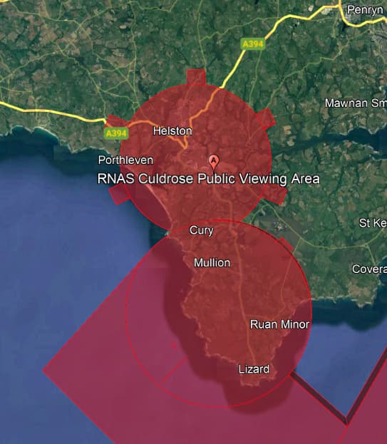
In Cornwall earlier this year, DJI blocks vast swathes because of RAF Culdrose. By the time I finally got an exemption, the weather had changed and it was too late. Where I was and the height I intended to operate at, you weren’t getting a helicopter into.
In some areas (e.g. Antarctic regions), there is sometimes no GPS signal and that’s that with DJI.
Now, before anyone gets upon his high horse, I am a responsible drone flier and also, as an aircraft owner, I’m acutely aware of what is and isn’t safe. It feels like it’s getting to a point where I can fly a plane in more places than a 249g drone! Which is all the way back to where I started with aerial photography.
So, my questions are
Does Litchi have enforced, no fly zones? Actually, I don’t care if it does so in sensible places like airfields and military zones.
Can I install Litchi on my (Android) mobile alongside Fly and switch between the 2 as necessary. Even with the DJI controller?
Someone in this forum mentioned that all DJI’s No Fly Zones are also enforced by Litchi due to an SDK-imposed default and that without express permission from DJI to fly in a specified restricted area, there is simply no way to bypass the NFZ flight embargo.
I happen to reside in a Third World backwater where my list of gripes runs the gamut from cratered lunar surface roads, roving banditos, erratic mains electricity supply, corrupt cops that demand cash at highway checkpoints, and numerous other surreal travails that one encounters here.
Despite all these inconveniences, I feel blessed when it comes to drone flying because there simply are no drone regulations here whatsoever, which leaves me to apply my own discretion and fly my drone fleet any way I please and over any area I choose on a whim.
This small consolation may not seem worthy of celebration by non-drone owners, but every time I read about the tightening restrictions imposed by the FAA and CAA on drone flights in the USA and EU, I really do count my lucky stars for the fact that I live way out in the lawless boonies where the few laws that do exist are regarded as thoughtful suggestions for which compliance is optional, rather than enforced binding obligations.
its not DJI that’s blocking that, its because RNAS Culdrose is an active military airbase with multiple runways and has the same restrictions as anyother airfield re NFZ’s, the problem is further impounded down that coast to the lizard by the fact that you’ve got a similar situation at Predannack a bit further down from Culdrose and as can be seen here their NFZ’s actually intersect around about Cury
The geo-zone restrictions that DJI imposes on us are incorporated into the drone. Therefore, no matter what application is used to fly the drone, those restrictions will remain in place. For example, if you wish to fly in a blue auhorization zone using Litchi, you will first be required to unlock that zone using the DJI software.
No, but they already loaded into your drone as explained above.
It seems that I will be looking at a switch to Autel. Whilst probably inferior in most respects to DJI “equivalents”, a great drone is no use if you cannot get it off the ground. DJI fast becoming the drone equivalent of Tantalus’s fruit.