I put a bunch (8 or so) of waypoints close to each other with focus on two POI’s. 1st four waypoints on POI one, last four waypoints on POI two. The 1st WP seemed to have triggered the “take photo” action but the rest seem off. Instead of photographing the POI’s, it took several photo’s from yards that was were further along the flight path. Flight speed is only 2 m/s so I don’t think that is the issue.
I even got a photo near (?) a waypoint that was not set for action “take photo”. So it seems there is some substantial delay somewhere.
Things I am thinking about:
Should I use path mode straight?
Is there some minimum space requirement between waypoints?
Should I set it to hover 2 seconds between each waypoint?
We need more info to answer.
Most importantly which drone model, then which app you fly with.
Ideally just paste a link to the flight: [GUIDE] How to Share a Flight or Folder
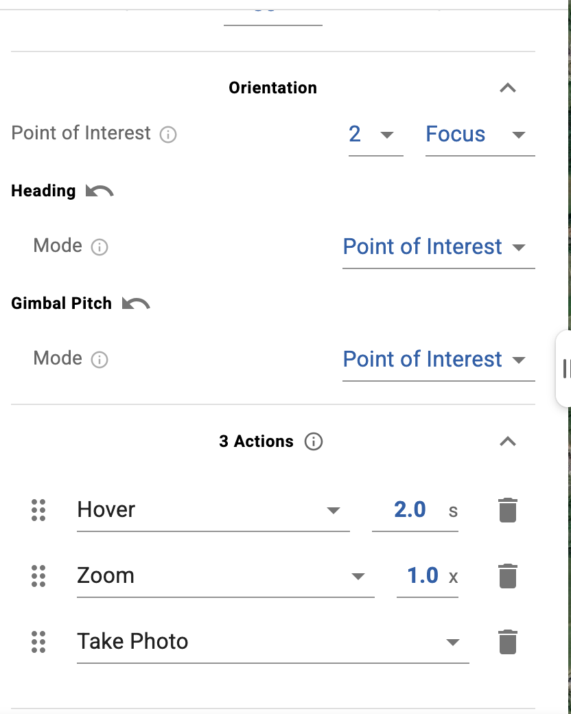
Hi @vico. I can share it privately with you if that is allowed? The drone is a DJI Mini 5 pro with the native DJI-app. I copy the kmz file manually to the drone. Most likely we’ll upgrade to a new Mavic Pro because of the zoom capabilities but I assume the setup will be largely identical.
With DJI Fly, waypoint mode is designed for shooting cinematic videos primarily. This means the drone will transition its heading and gimbal pitch from waypoint to waypoint. Because the rate of change during transition is limited by DJI (to achieve cinematic results), if 2 waypoints are very close to each other, the drone won’t have enough time to transition to your target heading or gimbal pitch. You can help it to have more time by reducing the speed between the 2 waypoints but in the end you’ll need some space between the waypoints anyway.
On top of this, remember that with DJI Fly’s waypoint mode, the drone will not stop at a waypoint unless there is a Hover action.
Straight line path mode probably won’t solve your issues but always worth trying.
There is no min. space between waypoints AFAIK.
@vico I’ve shared the problematic flight with you. I’ve created a straight line and hover scenario to test later as well. Thanks for the interesting information. I thought it would be more than fast enough for simple picture snapping. Alas, as I understand it without SDK-support, using lichi as a third party app is out of the question for both the mini 5 pro as for its bigger brother Mavic 4 pro. I best read up on the enterprise alternatives if these restrictions become a hindrance.
Speed is 2m/s, with waypoints close like that you will hit the min photo interval limit. Photos cannot be taken faster than every 2 sec for a Mini 5 Pro and that’s with JPG not RAW.
There seems to also be an issue with your flight regarding elevation, where did you plan/edit that flight? Hover the waypoints to see the issue with elevation data. By the way if you simulate the flight you will also see that the drone is not taking all photos (enable sound effects in settings).
I can report that 2 seconds of hover (cfr. my screenshot) fixes it perfectly. Next is to try 1 second. Oh excellent tip! I did not realise the simulation caught it. I planned it on the Lichi hub, exported the kmz and uploaded it to the drone. Maybe the skewed elevation data is because certain scripting is blocked with no script (guessing it might not have been able to import dem data)? Regardless the (large) elevation number, it was at safe altitude (did the elevation map on another website by auto interpolating all the points between the way points)
Would you happen to know whether the Mavic 4 pro can do it faster? Thinking more money buys faster processing:)
I used gpsvisualizer.com/profile_input and used the most matching dem from the dropdown “Add DEM elevation data”. I used a script to calculate a point every 10 meter between the way points. I asked the website the elevation data for every point. Some substraction math and voila, I get an idea if it is safe.
Ah the most expensive combo. DJI sure know how to draw you in:)