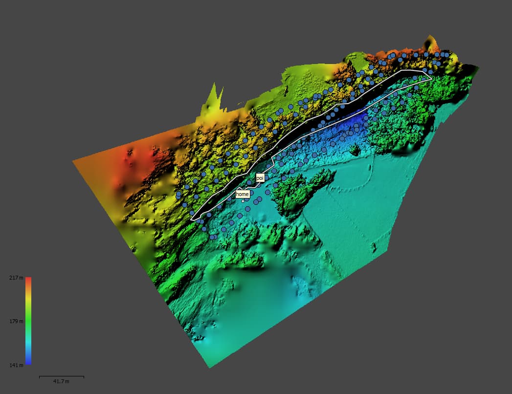
I have a flight plan generated using DJIFlightPlan, exported to csv for Litchi. Also, I have a DEM from the same area, originally the DEM was in bil format; I use ArcGIS to export the DEM to an ESRI ASCII Grid format (as indicated in the Litchi help section). First, I imported my flight plan into litchi in my computer, next I used the Import DEM option in the mission hub, find the DEM file in my computer and click import. The screen erases the imported project, and it turn into a white color and then nothing happens.
@Fabian_Lozano I have the same problem too! I was trying to import DEM from an esrii grid file (converted by QGIS) but the screen turn to gray and nothing happens!
Same Problem here.
I used a drone to create a DEM in Metashape Pro, exported the DEM Pseudo-Mercator as GeoTIFF.tif file. loaded it into Global Mapper (Trial) to export it as .asc …
My Workflow:
DEM (WGS 84 Pseudo-Mercator)
Export DEM (GeoTiff.tif)
Drag and Drop into Global Mapper
Right Click on Layer
Layer → EXPORT → Arc ASCII Grid → Keep "OK"ying everything → Save File as .asc
In LitchiHub: Import DEM → Load the exported .asc (No Tick at Force Square Cells)
The Size of the DEM is roughly 10-20 Acres, not very large. And it is not Square Shaped, more of a irregular shape. Is that a problem?
did someone solve it?
Images Shows Screenshot of DEM in Metashape Pro
I have the same problem with the same use case. I have a DEM from .img files from local lidar imagery that was brought into QGIS, then translated to an .asc file (using console command gdal_translate -a_srs EPSG:4326 -of AAIGrid). Screen turns grey and nothing happens.
I had the same problem and found a solution.
First, there are several types of ESRI ASCII grid format. At the top of the .asc file (opening with a text editor like Notepad++), we may find “ncols,” “nrows,” “xllcorner,” “yllcorner,” etc. I failed the import of DEM with a file that has “dx” and “dy” (cell size of x and y) and without “nodata_value.” The values of dx and dy were different with each other, because I generated an original DEM with a cell size set in meter. Litchi only allows .asc file of WGS84, and dx and dy in the .asc file can be different. Litchi may allow only .asc files with “cellsize.” This means that, the cell size of the original DEM must have been set with a degree for both latitude and longitude. So we should create an original DEM setting a cell size in a common delta latitude and delta longitude (such as around 4e-05 to generate around 4m cell size DEM at around lat=33.3). Then I opened the .asc file and replace the lines of dx and dy with cellsize. I also added a line of nodata_value simultaneously. As a result, my .asc file had lines like
ncols 177
nrows 150
xllcorner 134.11725
yllcorner 33.31606
cellsize 0.00004
nodata_value -36.9
This .asc file could be imported into the Litchi mission hub successfully.
2 Likes