It’s been working fine up until today, it went up to 60 meters and would not go any higher.
NAVDrone says that I can fly here higher than that but the app is refusing… Any idea what’s wrong?
I had 20 sats in view before taking off.
Have you flown higher than 60 meters at this exact location before? Can you fly higher than 60 meters using DJI Fly?
1 Like
I have not tried before in this location, I’m going to travel to a known good location today and see if I have the same problem.
I don’t use the DJI app, I’ve not used it in 3-4 months since buying a new phone… Is that a problem?
It is not a problem. However, if the same thing happens while using DJI Fly, it may help to confirm that it is a Geo-fencing problem.
If it only happens and that previous location, that would also point to Geo-fencing.
@Nathanael_Newton If the issue is not related to Geo-Fencing, check your Aircraft Settings and ensure that your “Maximum Altitude” isn’t set too low.
I am having the same issue with Litchi on my Android phone. Work fine last week now all the sudden will not let me go further than 160 ft away or 98 ft high from takeoff point no matter where I try it from. DJI fly app there is no issue at all. Also I’m getting an ESC short circuit warning on Litchi but there is nothing wrong with the ESC on my drone. I don’t get that warning on the DJI fly app. Everything works perfect on it I have even uninstalled and reinstalled Litchi several times and still does not work.
It was definitely a geofence issue. Thanks for your time
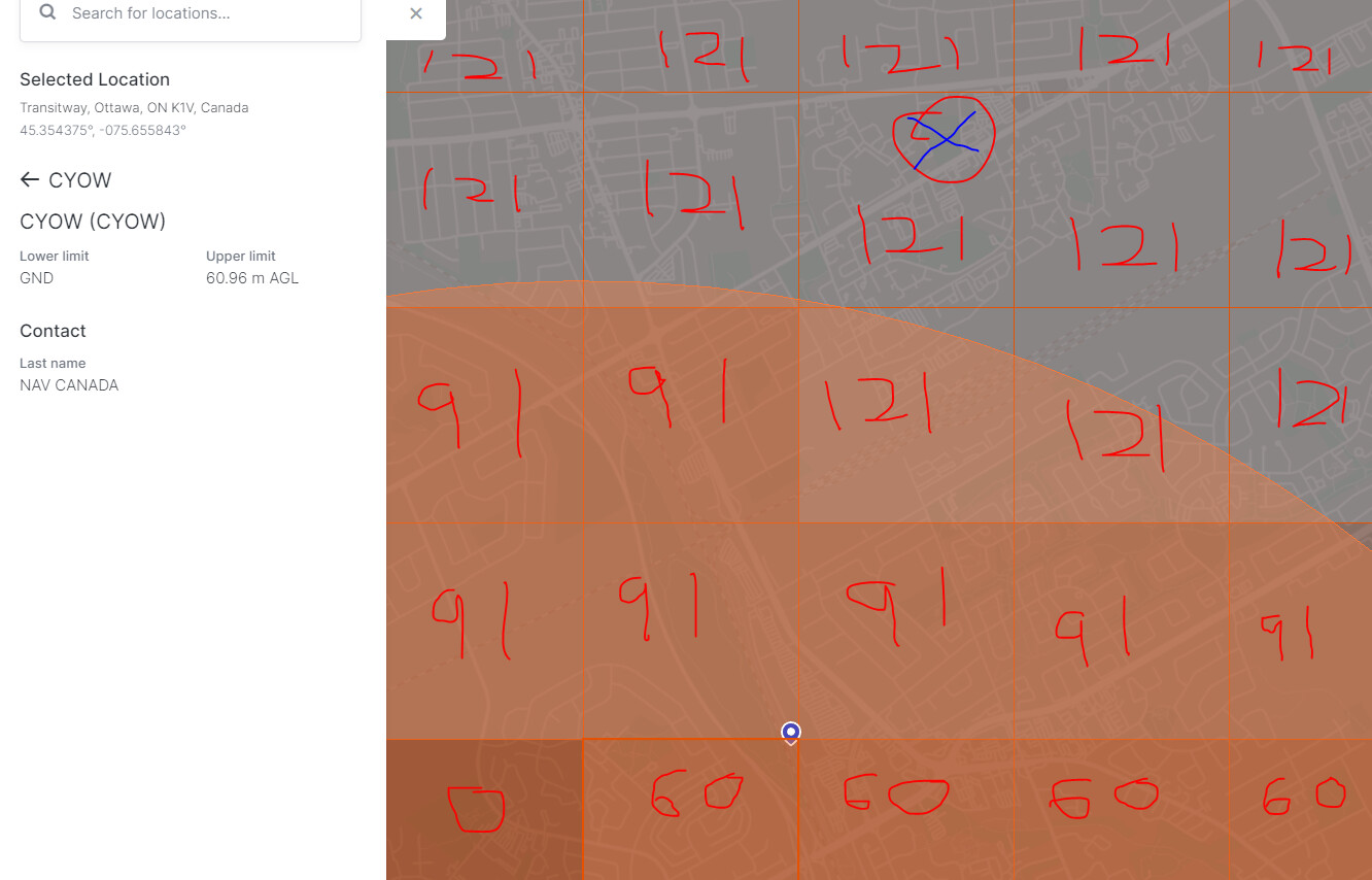
I’ve been examining the flight restrictions in the area and while there is a 60m AGL near where I’m trying to fly, it’s approximately 2.7 km from my take-off location with a 90m AGL between here and there.
Any idea why the app/drone is restricting in an area that’s not restricted?
AGL Map of the area, attempting to fly at the red circle/blue X
Had a similar problem myself and I’ve come to the conclusion that the area outlined on the map is not entirely accurate. It may cover a wider area. Also with my restriction I was able to get DJI to authorise my flight into the restricted zone however the Litchi app would not allow it. I could only do it with the DJI fly app.
It is not clear what you are trying to say here.
You don’t specify what type of may you are showing so I’m not sure what conclusion to draw from it.
To understand DJI’s geo-fencing you need to look at their geo-fencing maps (fly-safe.dji.com).
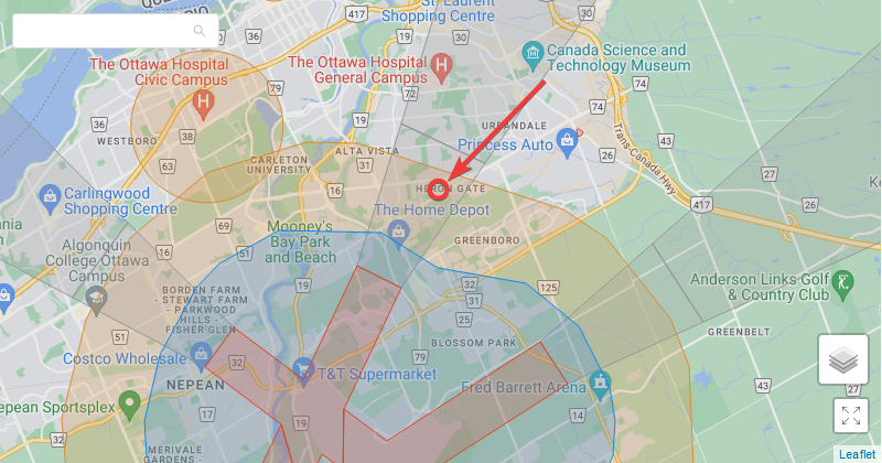
Here is a map of the area you pointed out. The arrow pointing to the red circle is the location you “X’ed” in your map above. It appears to be in an enhanced warning zone. If you were to try flying here using DJI Fly, the app will tell you what it was. If it is an enhanced warning zone, DJI Fly will have you check a checkbox signifying that understand the risks of flying at this location.
1 Like
OK that makes sense. I’m using the Nav Drone Map from Nav Canada (Canada’s FAA)
The flight restriction information does not match between the maps, DJI’s is more restrictive than Nav Drone. Thank you for the information.