Interesting. I switched to using “compass_heading” and I think I agree. Please test.
Do you know what the difference is between “compass_heading” and “gimbal_heading”? I had thought that “compass_heading” referred to the drone and that “gimbal_heading” referred to the gimbal. Maybe that was not correct. I haven’t seen any documentation on the Litchi csv format that describes the columns.
That’s how I’d take it as well, so if you were flying north with the drone facing west, the compass heading would be 0 (N), and the gimbal heading would be 270 (W)
Hi Martin,
That is not what I was trying to describe. Generally, both the camera (gimbal) and drone are pointing in the same direction. However, the camera is allowed to yaw relative to the aircraft body. My assumption was that “compass_heading” referred to the direction the aircraft body was pointing (not the direction the aircraft was flying). And the “gimbal_heading” was the direction the camera was pointing. These two values are always very close (only a few degrees difference.
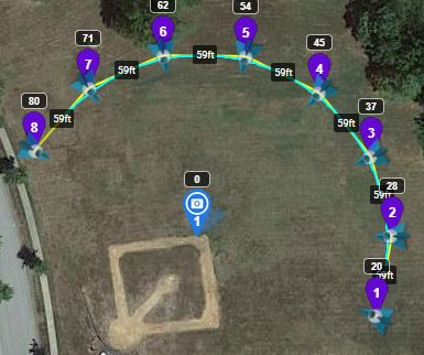
In the example below, both of these values point (roughly) at the POI, neither point along the direction of travel.
1 Like
Sorry it took so long to reply, I am a seasonal flyer. Yes, the changes seem to reflect my SQL version gimbal direction from a Mavic 2 Pro. Great job!! This saves me a few steps in converting these to Litchi/Maven.
One thing to consider would be to increase the first waypoint from home distance, as it is typical to fly 1/4 mile to the first waypoint.